Trisha Shetty (Editor)

Topographic isolation

Updated on
Edit
Like
Comment
Share on FacebookTweet on TwitterShare on LinkedInShare on Reddit
Topographic isolation

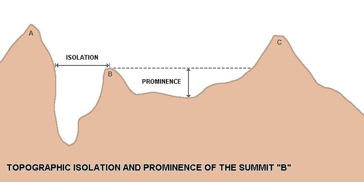
The topographic isolation of a summit is the minimum great-circle distance to a point of equal elevation, representing a radius of dominance in which the peak is the highest point. It can be calculated for small hills and islands as well as for major mountain peaks, and can even be calculated for submarine summits.

Contents

Isolation table

The following sortable table lists the Earth's 40 most topographically isolated summits.

Examples

  • The nearest peak to Germany's highest mountain, the 2,962-metre-high Zugspitze, that has a 2962-metre-contour is the Zwölferkogel (2,988 m) in Austria's Stubai Alps. The distance between the Zugspitze and this contour is 25.8 km; the Zugspitze is thus the highest peak for a radius of 25.8 km around. Its isolation is thus 25.8 km.
  • Because there are no higher mountains than Mount Everest, it has no definitive isolation. Many sources list its isolation as the circumference of the earth over the poles or – questionably, because there is no agreed definition – as half the earth's circumference.
  • After Mount Everest the Aconcagua, highest mountain of the American continents, has the greatest isolation of all mountains. There is no higher land for 16,534 kilometres when its height is first exceeded by Tirich Mir in the Hindu Kush.
  • Mont Blanc is the highest mountain of the Alps. The geographically nearest higher mountains are all in the Caucasus. The Kukurtlu (4,912 m), which rises near the Elbrus (5,633 m), is the reference peak for Mont Blanc.
  • References

    Topographic isolation Wikipedia


    Similar Topics