Samiksha Jaiswal (Editor)

Timeline of the 2013 Atlantic hurricane season

Updated on
Edit
Like
Comment
Share on FacebookTweet on TwitterShare on LinkedInShare on Reddit
Timeline of the 2013 Atlantic hurricane season

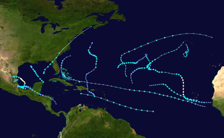
The 2013 Atlantic hurricane season was a below-average season, featuring the fewest number of hurricanes since 1982. Although Tropical Storm Andrea formed on June 5, the season officially began on June 1 and ended on November 30, dates that conventionally delimit the period of each year when most tropical cyclones develop in the Atlantic basin. The season's final storm, an unnamed subtropical storm, dissipated on December 7.

Contents

The season produced fifteen tropical or subtropical cyclones, of which fourteen intensified into tropical or subtropical storms; two became hurricanes, but none further intensified into major hurricanes, the first such occurrence since the 1994 season. Despite the slow season, Mexico was impacted by numerous tropical cyclones, the worst being Tropical Storm Fernand and Hurricane Ingrid. The former moved ashore in late August, killing 14 and causing millions in damage, while the latter moved ashore in mid-September, killing 23 and causing $1.5 billion (2013 USD) in damage. Only one tropical storm, Andrea, made landfall on the United States during the 2013 season; it killed four and brought tornadoes, heavy rainfall, and flooding to a large section of the East Coast and Atlantic Canada.

This timeline includes information that was not operationally released, meaning that data from post-storm reviews by the National Hurricane Center, such as a storm that was not operationally warned upon, has been included. This timeline documents tropical cyclone formations, strengthening, weakening, landfalls, extratropical transitions, and dissipations during the season.

June

June 1

  • The 2013 Atlantic hurricane season officially begins.
  • June 5

  • 18:00 UTC (2:00 p.m. EDT) – Tropical Storm Andrea develops from an area of low pressure roughly 310 mi (500 km) southwest of Saint Petersburg, Florida.
  • June 6

  • 12:00 UTC (8:00 a.m. EDT) – Tropical Storm Andrea attains maximum sustained winds of 65 mph (100 km/h).
  • 22:00 UTC (6:00 p.m. EDT) – Tropical Storm Andrea makes landfall about 10 mi (15 km) south of Steinhatchee, Florida, with winds of 60 mph (95 km/h), and simultaneously attains its peak intensity with a minimum barometric pressure of 992 mb (hPa; 29.30 inHg).
  • June 7

  • 18:00 UTC (2:00 p.m. EDT) – Tropical Storm Andrea transitions into an extratropical cyclone over northeastern South Carolina.
  • June 17

  • 12:00 UTC (7:00 a.m. CDT) – Tropical Depression Two develops from an area of low pressure roughly 25 mi (40 km) north-northwest of La Ceiba, Honduras.
  • 22:00 UTC (5:00 p.m. CDT) – Tropical Depression Two makes its first landfall near Big Creek, Honduras, with winds of 35 mph (55 km/h).
  • June 19

  • 12:00 UTC (7:00 a.m. CDT) – Tropical Depression Two intensifies into Tropical Storm Barry about 105 mi (165 km) north-northeast of Coatzacoalcos, Mexico.
  • June 20

  • 00:00 UTC (7:00 p.m. CDT June 19) – Tropical Storm Barry attains its peak intensity with maximum sustained winds of 45 mph (75 km/h) and a minimum barometric pressure of 1003 mb (hPa; 29.62 inHg).
  • 11:15 UTC (6:15 a.m. CDT) – Tropical Storm Barry makes its second and final landfall near Laguna La Mancha, Mexico, with winds of 45 mph (75 km/h).
  • 18:00 UTC (1:00 p.m. CDT) – Tropical Storm Barry weakens to a tropical depression.
  • June 21

  • 00:00 UTC (7:00 p.m. CDT June 20) – Tropical Depression Barry degenerates into a non-convective remnant area of low pressure over the Mexican state of Puebla.
  • July

    July 7

  • 12:00 UTC (8:00 a.m. AST) – Tropical Storm Chantal develops from an area of low pressure roughly 1245 mi (2000 km) east-southeast of Barbados.
  • July 9

  • 12:00 UTC (8:00 a.m. AST) – Tropical Storm Chantal attains its peak intensity with maximum sustained winds of 65 mph (100 km/h) and a minimum barometric pressure of 1003 mb (hPa; 29.62 inHg) as it passes through the central Lesser Antilles.
  • July 10

  • 18:00 UTC (2:00 p.m. EDT) – Tropical Storm Chantal dissipates south of Hispaniola.
  • July 23

  • 18:00 UTC (2:00 p.m. AST) – Tropical Depression Four develops from an area of low pressure about 175 mi (280 km) south-southeast of the Cape Verde Islands.
  • July 24

  • 06:00 UTC (2:00 a.m. AST) – Tropical Depression Four intensifies into Tropical Storm Dorian roughly 185 mi (300 km) west-southwest of the southernmost Cape Verde Islands.
  • July 25

  • 06:00 UTC (2:00 a.m. AST) – Tropical Storm Dorian attains its peak intensity with maximum sustained winds of 60 mph (95 km/h) and a minimum barometric pressure of 1002 mb (hPa; 29.59 inHg).
  • July 27

  • 18:00 UTC (2:00 p.m. AST) – Tropical Storm Dorian degenerates into a trough of low pressure about 575 mi (925 km) east of the northeastern Leeward Islands.
  • August

    August 2

  • 18:00 UTC (2:00 p.m. EDT) – The remnants of Tropical Storm Dorian regenerate into a tropical depression roughly 75 mi (120 km) northwest of Freeport, Bahamas.
  • August 3

  • 18:00 UTC (2:00 p.m. EDT) – Tropical Depression Dorian degenerates into a remnant area of low pressure about 165 mi (265 km) southeast of Charleston, South Carolina.
  • August 15

  • 00:00 UTC (8:00 p.m. AST August 14) – Tropical Depression Five develops from an area of low pressure roughly 70 mi (110 km) south of Praia, Cape Verde.
  • 06:00 UTC (2:00 a.m. AST) – Tropical Depression Five intensifies into Tropical Storm Erin.
  • August 17

  • 00:00 UTC (8:00 p.m. AST August 16) – Tropical Storm Erin attains its peak intensity with maximum sustained winds of 45 mph (75 km/h) and a minimum barometric pressure of 1006 mb (hPa; 29.71 inHg).
  • August 18

  • 06:00 UTC (2:00 a.m. AST) – Tropical Storm Erin degenerates into a non-convective remnant area of low pressure about midway between the western coast of Africa and the northern Leeward Islands.
  • August 25

  • 12:00 UTC (7:00 a.m. CDT) – Tropical Depression Six develops from an area of low pressure roughly 40 mi (65 km) north-northeast of Coatzacoalcos, Mexico.
  • 18:00 UTC (1:00 p.m. CDT) – Tropical Depression Six intensifies into Tropical Storm Fernand about 70 mi (110 km) east-southeast of Veracruz, Mexico.
  • August 26

  • 00:00 UTC (7:00 p.m. CDT August 25) – Tropical Storm Fernand attains its peak intensity with maximum sustained winds of 60 mph (95 km/h) and a minimum barometric pressure of 1001 mb (hPa; 29.56 inHg).
  • 04:45 UTC (11:45 p.m. CDT August 25) – Tropical Storm Fernand makes landfall near Zempoala, Mexico, with winds of 60 mph (95 km/h).
  • 12:00 UTC (7:00 a.m. CDT) – Tropical Storm Fernand weakens to a tropical depression.
  • 18:00 UTC (1:00 p.m. CDT) – Tropical Depression Fernand degenerates into a non-convective remnant area of low pressure near Tulancingo, Mexico.
  • September

    September 4

  • 18:00 UTC (2:00 p.m. AST) – Tropical Depression Seven develops from an area of low pressure roughly 115 mi (185 km) south-southeast of Puerto Rico.
  • September 5

  • 18:00 UTC (2:00 p.m. AST) – Tropical Depression Seven degenerates into a tropical disturbance near the eastern tip of Hispaniola.
  • September 6

  • 12:00 UTC (7:00 a.m. CDT) – Tropical Depression Eight develops from an area of low pressure roughly 30 mi (50 km) east-northeast of Tampico, Mexico.
  • 18:00 UTC (1:00 p.m. CDT) – Tropical Depression Eight attains its peak intensity with maximum sustained winds of 35 mph (55 km/h) and a minimum barometric pressure of 1008 mb (29.77 inHg) and simultaneously makes landfall near Tampico, Mexico.
  • September 7

  • 06:00 UTC (1:00 a.m. CDT) – Tropical Depression Eight degenerates into a non-convective remnant area of low pressure roughly 95 mi (155 km) southwest of Tampico, Mexico.
  • September 8

  • 18:00 UTC (2:00 p.m. AST) – Tropical Depression Nine develops from an area of low pressure about 225 mi (360 km) west-southwest of Dakar, Africa.
  • September 9

  • 06:00 UTC (2:00 a.m. AST) – Tropical Depression Nine intensifies into Tropical Storm Humberto roughly 145 mi (235 km) southeast of Praia, Cape Verde.
  • September 10

  • 00:00 UTC (8:00 p.m. AST September 9) – The remnants of Tropical Depression Seven regenerate into a tropical depression about 345 mi (555 km) south of Bermuda.
  • 06:00 UTC (2:00 a.m. AST) – Tropical Depression Seven intensifies into Tropical Storm Gabrielle roughly 225 mi (360 km) south of Bermuda.
  • 12:00 UTC (8:00 a.m. AST) – Tropical Storm Gabrielle attains its peak intensity with maximum sustained winds of 65 mph (100 km/h) and a minimum barometric pressure of 1003 mb (hPa; 29.59 inHg).
  • September 11

  • 12:00 UTC (8:00 a.m. AST) – Tropical Storm Humberto intensifies into a Category 1 hurricane, the first of the 2013 season, about 370 mi (595 km) west-northwest of Praia, Cape Verde.
  • 18:00 UTC (2:00 p.m. AST) – Hurricane Humberto attains its peak intensity with maximum sustained winds of 90 mph (150 km) and a minimum barometric pressure of 979 mb (hPa; 28.91 inHg).
  • September 12

  • 00:00 UTC (8:00 p.m. AST September 11) – Tropical Storm Gabrielle weakens to a tropical depression.
  • 12:00 UTC (8:00 a.m. AST) – Tropical Depression Gabrielle re-intensifies into a tropical storm about 190 mi (305 km) northwest of Bermuda.
  • 18:00 UTC (1:00 p.m. CDT) – Tropical Depression Ten develops from an area of low pressure 175 mi (280 km) east-northwest of Veracruz, Mexico.
  • September 13

  • 06:00 UTC (2:00 a.m. AST) – Tropical Storm Gabrielle weakens to a tropical depression for a second time.
  • 06:00 UTC (2:00 a.m. AST) – Hurricane Humberto weakens to a tropical storm about 755 mi (1,215 km) northwest of Praia, Cape Verde.
  • 12:00 UTC (7:00 a.m. CDT) – Tropical Depression Ten intensifies into Tropical Storm Ingrid roughly 70 mi (110 km) east of Veracruz.
  • 18:00 UTC (2:00 p.m. AST) – Tropical Depression Gabrielle dissipates north-northwest of Bermuda.
  • September 14

  • 00:00 UTC (8:00 p.m. AST September 13) – Tropical Storm Humberto degenerates into a non-convective remnant area of low pressure about 900 mi (1,450 km) northwest of Praia, Cape Verde.
  • 18:00 UTC (1:00 p.m. CDT) – Tropical Storm Ingrid intensifies into a Category 1 hurricane about 170 mi (275 km) northeast of Veracruz, Mexico.
  • September 15

  • 00:00 UTC (8:00 p.m. AST September 14) – The remnants of Tropical Storm Humberto regenerate into a tropical storm roughly 1,095 mi (1,760 km) southwest of Ponta Delgada, Azores.
  • 00:00 UTC (7:00 p.m. CDT September 14) – Hurricane Ingrid attains its peak intensity with maximum sustained winds of 85 mph (140 km/h) and a minimum barometric pressure of 983 mb (hPa; 29.03 inHg).
  • September 16

  • 06:00 UTC (1:00 a.m. CDT) – Hurricane Ingrid weakens to a tropical storm about 100 mi (160 km) northeast of Tampico, Mexico.
  • 11:15 UTC (6:15 a.m. CDT) – Tropical Storm Ingrid makes landfall near La Pesca, Mexico, with winds of 65 mph (100 km/h).
  • September 17

  • 00:00 UTC (7:00 p.m. CDT September 16) – Tropical Storm Ingrid weakens to a tropical depression about 90 mi (150 km/h) west of La Pesca, Mexico.
  • 06:00 UTC (1:00 a.m. CDT) – Tropical Depression Ingrid degenerates into a non-convective remnant area of low pressure about 120 mi (195 km) west of La Pesca, Mexico.
  • 12:00 UTC (8:00 a.m. AST) – Tropical Storm Humberto transitions into a subtropical storm.
  • September 18

  • 06:00 UTC (2:00 a.m. AST) – Subtropical Storm Humberto weakens to a subtropical depression about 1,115 mi (1,795 km) southwest of Ponta Delgada.
  • September 19

  • 12:00 UTC (8:00 a.m. AST) – Subtropical Depression Humberto dissipates southwest of the Azores.
  • September 29

  • 00:00 UTC (8:00 p.m. AST September 28) – Tropical Depression Eleven develops from an area of low pressure about 910 mi (1,465 km) east-northeast of the Leeward Islands.
  • September 30

  • 06:00 UTC (2:00 a.m. AST) – Tropical Depression Eleven intensifies into Tropical Storm Jerry about 1,150 mi (1,850 km) west-southwest of the Azores.
  • October

    October 1

  • 00:00 UTC (8:00 p.m. AST September 31) – Tropical Storm Jerry attains its peak intensity with maximum sustained winds of 50 mph (85 km/h) and a minimum barometric pressure of 1005 mb (hPa; 29.68 inHg).
  • October 3

  • 06:00 UTC (1:00 a.m. CDT) – Tropical Storm Karen develops from an area of low pressure about 35 mi (55 km) north of Cancun, Mexico.
  • 12:00 UTC (7:00 a.m. CDT) – Tropical Storm Karen attains its peak intensity with maximum sustained winds of 65 mph (100 km/h).
  • 18:00 UTC (2:00 p.m. AST) – Tropical Storm Jerry degenerates into a non-convective remnant area of low pressure about 770 mi (1,240 km) southwest of the central Azores.
  • 21:00 UTC (4:00 p.m. CDT) – Tropical Storm Karen attains its peak intensity with a minimum barometric pressure of 998 mb (hPa; 29.47 inHg).
  • October 6

  • 00:00 UTC (7:00 p.m. CDT October 5) – Tropical Storm Karen weakens to a tropical depression about 160 mi (260 km) southwest of New Orleans, Louisiana.
  • 12:00 UTC (7:00 a.m. CDT) – Tropical Depression Karen dissipates south of the south-central coast of Louisiana.
  • October 21

  • 06:00 UTC (2:00 a.m. AST) – Tropical Depression Thirteen develops from an area of low pressure about 620 mi (1,000 km) east-southeast of Bermuda.
  • 12:00 UTC (8:00 a.m. AST) – Tropical Depression Thirteen intensifies into Tropical Storm Lorenzo about 615 mi (990 km) southeast of Bermuda.
  • October 22

  • 12:00 UTC (8:00 a.m. AST) – Tropical Storm Lorenzo attains its peak intensity with maximum sustained winds of 50 mph (85 km/h) and a minimum barometric pressure of 1000 mb (hPa; 29.53 inHg).
  • October 24

  • 00:00 UTC (8:00 p.m. AST October 23) – Tropical Storm Lorenzo weakens to a tropical depression.
  • 12:00 UTC (8:00 a.m. AST) – Tropical Depression Lorenzo dissipates about 840 mi (1,350 km) west-southwest of Flores Island, Azores.
  • November

    November 18

  • 12:00 UTC (7:00 a.m. AST) – Subtropical Storm Melissa develops from an area of low pressure about 720 mi (1,160 km) east-southeast of Bermuda.
  • November 20

  • 06:00 UTC (1:00 a.m. AST) – Subtropical Storm Melissa transitions into a tropical storm about 775 mi (1,245 km) east-northeast of Bermuda.
  • November 21

  • 12:00 UTC (7:00 a.m. AST) – Tropical Storm Melissa attains its peak intensity with maximum sustained winds of 65 mph (100 km/h) and a minimum barometric pressure of 980 mb (hPa; 28.94 inHg).
  • November 22

  • 00:00 UTC (7:00 p.m. AST November 21) – Tropical Storm Melissa degenerates into a non-convective remnant area of low pressure about 140 mi (220 km) north-northeast of Flores Island, Azores.
  • November 30

  • The 2013 Atlantic hurricane season officially ends.
  • December

    December 5

  • 00:00 UTC (7:00 p.m. AST December 4) – A subtropical storm develops from an area of low pressure about 385 mi (620 km) south of the Azores and simultaneously attains its peak intensity with maximum sustained winds of 50 mph (85 km/h) and a minimum barometric pressure of 997 mb (hPa; 29.44 inHg).
  • December 7

  • 06:00 UTC (1:00 a.m. AST) – The subtropical storm degenerates into a non-convective remnant area of low pressure about 105 mi (165 km) south of the Azores.
  • References

    Timeline of the 2013 Atlantic hurricane season Wikipedia