
- left Arroyo de las Palmas - average 42.5 cu ft/s (1 m/s) Length 193 km Basin area 4,532 km² | - elevation 614 ft (187 m) - elevation 0 ft (0 m) Discharge 1.203 m³/s Basin area 4,532 km² | |
 | ||
- location Municipality of Ensenada | ||
Man rescued from gully in tijuana river valley
The Tijuana River (Spanish: Río Tijuana) is an intermittent river, 120 mi (195 km) long, near the Pacific coast of northern Baja California state in northwestern Mexico and Southern California in the western United States.
Contents
- Man rescued from gully in tijuana river valley
- Map of Tijuana River Imperial Beach CA USA
- LocationEdit
- DescriptionEdit
- Nature reservesEdit
- Wastewater treatmentEdit
- ParksEdit
- SurfingEdit
- References
Map of Tijuana River, Imperial Beach, CA, USA
LocationEdit
The Tijuana River drains an arid area along the U.S.—Mexico border, flowing through Mexico for most its course then crossing the border into Southern California for its lower 5 mi (8 km) to empty into the ocean in an estuary on the southern edge of San Diego.
The Tijuana River has two main tributaries. One the Arroyo de Alamar or Rio Alamar, runs in its upper reaches in the United States as Cottonwood Creek. It runs from its source in the Laguna Mountains southwestward where it is impounded in by two dams, Barrett and Morena, to supply water to the city of San Diego. Cottonwood Creek is joined by the Tecate Creek before it enters Mexico where it is known as the Arroyo de Alamar from the point where it enters Mexico to its confluence with the larger tributary, the Arroyo de las Palmas, that forms the headwaters of the Tijuana River within the city.
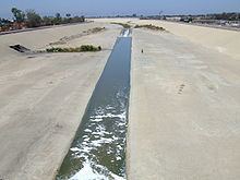
The Arroyo de las Palmas, main tributary of the Tijuana River, flows out of the mountains to the east into the reservoir behind the Abelardo L. Rodríguez Dam. Downstream from the Rodríguez Dam water flows through Tijuana in a concrete channel to the international border, there it continues west through the Tijuana River Valley for a distance of about nine miles to the estuary and then to the Pacific Ocean.
Its lower reaches provide the last undeveloped coast wetlands in San Diego County amidst a highly urbanized environment at the southern city limits of Imperial Beach. The river has been the subject of great controversy in recent decades regarding pollution, flood control, and U.S. border protection.
DescriptionEdit
The Tijuana River rises in the Sierra de Juárez of northern Baja California, approximately 45 mi (70 km) ENE of Ensenada. It flows WNW through Tijuana, crossing the border approximately 5 mi (8 km) from the Pacific. It flows west, just skirting the international border south of the San Ysidro section of San Diego. The lower 2 mi (3 km) of the river form the broad mud flat estuary, and the Tijuana River Estuary is a rich habitat for wildlife, including over 370 species of birds. It is Southern California's largest coastal wetland. It is naturally prone to flooding during heavy rains. The Tijuana River enters the Pacific 10 mi (15 km) south of downtown San Diego at the southern city limits of Imperial Beach.
The river is impounded in Mexico southeast of Tijuana by the Abelardo L. Rodríguez Dam for drinking water and irrigation. Former Baja California Governor Milton Castellanos Everardo constructed concrete barriers along the riverbank to prevent flooding during his tenure. The United States was suppose to build a complementary system of barriers to ensure flooding waters didn't flow back in to Mexico, but instead adopted a dissipator flood control plan under the direction of the San Diego City Council, supported by ecologists, which preserved the estuary, which was then designated a wildlife sanctuary.
The majority of its watershed is within Mexico, between Mesa de Otay to the east, and hills to the west.
Nature reservesEdit
The Tijuana River National Estuarine Research Reserve protects 2,293 acres (928 ha) and studies the Tijuana River Estuary. It was established as part of the National Estuarine Research Reserve system in the United States. The reserve is managed in part as a Biological Field Station by the San Diego State University (SDSU) College of Sciences, which also protects part of the estuary near the ocean within the United States.
The Tijuana Slough National Wildlife Refuge is part of the San Diego National Wildlife Refuge Complex, and is also within the Estuarine Research Reserve. The Tijuana Slough Refuge protects one of southern California's largest remaining salt marshes without a road or railroad trestle running through it. Designated as a Globally Important Bird Area by the American Bird Conservancy, over 370 species of birds have been sighted on the refuge.
Wastewater treatmentEdit
The river has been used as a wastewater conduit since at least the early 20th century. As such, the issue of sewage in the Tijuana River predates other news stories about the Mexico-United States border within the San Diego–Tijuana region by several decades. Raw sewage overflows on the Mexican side, from canyons along the river, are a recurring problem despite cross-border efforts to clean it up. In addition to sewage, trash is carried downstream causing damage to vegetation and contributes to flooding.
The first attempt to deal with sewage flowing into the Tijuana River was the creation of the International Outfall, a marine outfall, which was completed in 1939, but was proven to be inadequate as early as the late 1940s. By the 1950s, there was over 4 million gallons of sewage flowing into the river each day. Usage of the outfall ended in 1962 due to the completion of a pumping plant, which discharged untreated sewage into the Pacific Ocean; the pumping plant broke down in 1975. During the 1970s up to ten million gallons of sewage entered the river each day from Tijuana.
Partial progress was made in the 1980s with a Clean Water Grant from the U.S. Environmental Protection Agency to improve wastewater treatment, by creating the San Diego-Tijuana Wastewater Treatment Plant to protect estuary waters. In 1990, Mexico agreed to pay $41 million of the $192 million to construct the plant. The plant plant was completed in 1997. Finishing in January 2011, the plant received a $93 million upgrade. Other sewage that would have flown into Tijuana river is treated at the Punta Bandara treatment plant; it handles 30 million gallons of sewage a day, however its discharge doesn't meet Mexican water standards sometimes causing closure of beaches as far north as Coronado.
According to a 1993 report by the city of San Diego, the city had collected an average of 13 million gallons (50 million liters) per day of raw sewage, that then was treated by the Point Loma wastewater treatment plant; this is down from 20 million gallons per day in 1997 being treated by the city of San Diego, which it had received from Tijuana. Since 1998 the U.S. EPA has funded $42 million on sewage projects in Tijuana. In 2015, the amount of sewage treated on a dry day remained the same, at 13 million gallons; however when it rains, the amount of sewage can increase to 27 million gallons a day, and the pump which funnels water to the treatment plant is shut off so it isn't overcome. In January 2017, the Punta Bandaras treatment plant, officially known as San Antonio de los Buenos plant, treated 15 million gallons of sewage a day to standards below U.S. secondary-level standards, pumping the water out into the Pacific Ocean at La Playa. Due to the sewage in the river, it has been called "one of the most polluted waterways in the country"; this has led to a multitude of beach closures in Imperial Beach. Each year the beach at Border Field State Park is closed for 233 days.
In February 2017, over 143 million gallons of sewage entered into the river, larger than the more common few million gallons amount of sewage that is routine; later the amount of sewage was revised upwards to over 200 million. However, a Mexican water official claims that the spill was only 30 million gallons. The spill is the largest to occur into the river in over ten years. The sewage spill was not initially reported by Mexican officials, but was noticed by residents on the South Bay coast. The impact of the spill effected waters as far north as Coronado, and was described by Imperial Beach Mayor Serge Dedina as "a tsunami of sewage", and described the flow of sewage into the river as "deliberate". According to the International Boundary Water Commission, the sewage discharge was due to a repair of a sewer pipe near the Rio Alamar. The sewage was first noticed in the middle of the month. Repairs of the sewer pipe was completed in late February 2017, but the exact dates when the sewage began entering the river, and stopped was unknown as of March 2017, leading to calls for an investigation. By mid-March 2017, the California Department of Environmental Health had found that the water quality had returned to within health standards, opening beaches up to Coronado.
ParksEdit
The Tijuana River Valley Regional Park is located in the Tijuana River Valley district of San Diego. It protects over 1,800 acres (730 ha), including dense riparian forests along the Tijuana River. It has an extensive system of trails for walking and equestrian access.
SurfingEdit
The mouth of the Tijuana River is the location of the Tijuana Sloughs big-wave surfing break, which is a mile off shore. Winter waves can be as high as 12 feet or greater; 20 foot high waves are not unknown to occur. Surfing has been occurring at the slough since at least 1937. It has been described as the "gold standard" in Southern California; with surfers using it as a training ground for surf found in Hawaii.
Surfing at the sloughs has impacted the evolution of surfing culture, as well as regional culture. Lifeguards have watched over the area since 1939. Sewage from the river impacts water quality, which can lead to surfers becoming ill; one source describes that area as "virtually unsurfable due to pollution."