Samiksha Jaiswal (Editor)

Thunder Bay District

Updated on
Edit
Like
Comment
Share on FacebookTweet on TwitterShare on LinkedInShare on Reddit
Country
  
Canada

Region
  
Northwestern Ontario

Elevation
  
220 m (720 ft)

Area
  
103,706 km²

Population
  
146,057 (2011)

Province
  
Ontario

Created
  
1871

Highest elevation
  
640 m (2,100 ft)

Local time
  
Friday 7:08 AM

Thunder Bay District

Weather
  
-5°C, Wind SW at 3 km/h, 86% Humidity

Colleges and Universities
  
Lakehead University, Confederation College

Points of interest
  
Fort William Historical, Mount McKay, Terry Fox Memorial and Look, Hillcrest Park, Thunder Bay Soroptimi

Jessica mcleod thunder bay district health unit


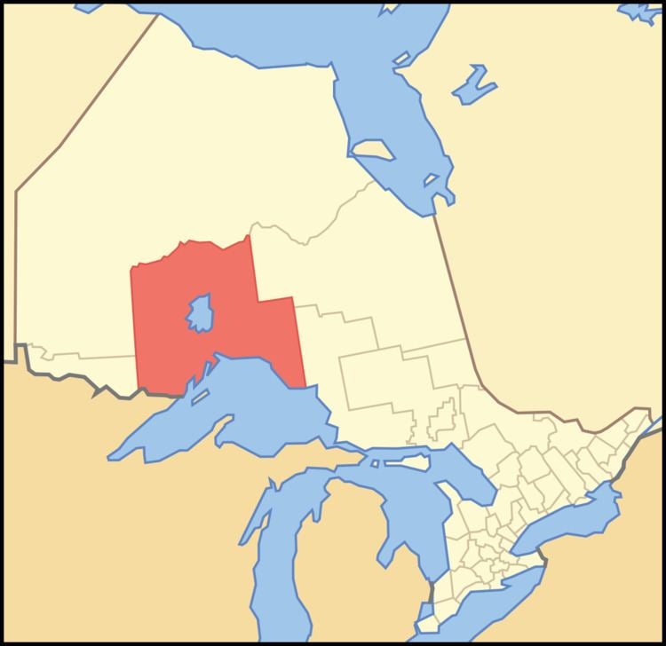
Thunder Bay District is a district and census division in Northwestern Ontario in the Canadian province of Ontario. The district seat is Thunder Bay.

Contents

Map of Thunder Bay District, ON, Canada

In 2011, the population was 146,057. The land area is 103,719.51 square kilometres (40,046.33 sq mi); the population density was 1.4 per square kilometre (3.6/sq mi). Most of the district (93.5%) is unincorporated and part of the Unorganized Thunder Bay District.

History

Thunder Bay District was created in 1871 by provincial statute from the western half of Algoma District, named after a large bay on the north shore of Lake Superior. Its northern and western boundaries were uncertain until Ontario's right to Northwestern Ontario was determined by the Judicial Committee of the Privy Council. Until about 1902 it was often called Algoma West from the name of the provincial constituency established in 1885.

The following districts include areas that were formerly part of Thunder Bay District:

  • Rainy River, created in 1885
  • Kenora, created in 1907 from Rainy River District
  • Cochrane, created in 1921
  • Municipalities

  • City of Thunder Bay
  • Municipality (town) of Greenstone
  • Town of Marathon
  • Township of Conmee
  • Township of Dorion
  • Township of Gillies
  • Township of Manitouwadge
  • Municipality (township) of Neebing
  • Township of Nipigon
  • Township of O'Connor
  • Municipality (township) of Oliver Paipoonge
  • Township of Red Rock
  • Township of Schreiber
  • Township of Shuniah
  • Township of Terrace Bay
  • First Nations and their Indian Reserves

  • Animbiigoo Zaagi'igan Anishinaabek First Nation: Lake Nipigon
  • Aroland First Nation: Aroland Settlement (Aroland 83)
  • Biinjitiwabik Zaaging Anishnabek First Nation (Rocky Bay): Rocky Bay 1
  • Bingwi Neyaashi Anishinaabek First Nation (Sand Point)
  • Fort William First Nation: Fort William 52
  • Ginoogaming First Nation: Ginoogaming (Long Lac 77)
  • Kiashke Zaaging Anishinaabek First Nation (Gull Bay): Gull River 55
  • Lac des Mille Lacs First Nation: Lac des Mille Lacs 22A1, Seine River 22A2
  • Long Lake 58 First Nation: Long Lake 58
  • Namaygoosisagagun First Nation (non-status)
  • Ojibway Nation of Saugeen First Nation (Savant Lake): Ojibway Nation of Saugeen
  • Ojibways of the Pic River First Nation: Pic River 50
  • Pays Plat First Nation: Pays Plat 51
  • Pic Mobert First Nation: Pic Mobert North, Pic Mobert South
  • Red Rock First Nation (Lake Helen): Lake Helen 53A, Red Rock 53
  • Seine River First Nation: Seine River 23A, Seine River 23B
  • Whitesand First Nation: Armstrong Settlement, Whitesand
  • Unorganized areas

  • Thunder Bay, Unorganized (including the local services boards of Armstrong, East Gorham, Hurkett, Kaministiquia, Lappe, Nolalu, Rossport, Savant Lake, Shebandowan, and Upsala)
  • Demographics

    Almost 80 per cent of the district's population lives in the city of Thunder Bay Census Metropolitan Area; no other community in the district exceeds 7,000 in population.

    Historic populations:

  • Population in 2001: 150,860
  • Population in 1996: 157,619
  • References

    Thunder Bay District Wikipedia