
Demonym(s) Tesselaar, Texelaar Postcode 1790–1797 Area 463.3 km² | Elevation 2 m (7 ft) Time zone CET (UTC+1) Area code 0222 | |
 | ||
Weather 11°C, Wind SW at 31 km/h, 84% Humidity Points of interest Ecomare, Kaap Skil, Eierland Lighthouse, West Frisian Islands, Schipbreuk‑ en Juttersmu | ||
The island texel the netherlands
Texel ( [ˈtɛsəl]) is a municipality and an island with a population of 13,641 in the province of North Holland in the Netherlands. It is the largest and most populated island of the West Frisian Islands in the Wadden Sea. The island is situated north of Den Helder, northeast of Noorderhaaks, also known as "Razende Bol" and southwest of Vlieland.
Contents
- The island texel the netherlands
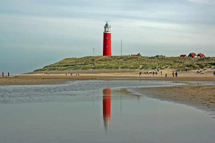
- Map of Texel Netherlands
- The beautiful wadden island of texel holland holiday
- Name
- History
- Geography
- Landscape
- Economy
- Local government
- Transport
- References
Map of Texel, Netherlands
The beautiful wadden island of texel holland holiday
Name
The name Texel is Frisian, but because of historical sound-changes in Dutch, where all -x- sounds have been replaced with -s- sounds (compare for instance English fox, Frisian fokse, German Fuchs with Dutch vos), the name is typically pronounced Tessel in Dutch.
History
In the early Middle Ages and before, Texel and Wieringen may have been much bigger and met each other as opposite banks of the Marsdiep, which was then a river with banks of permanent land: see here.
In the 13th century Ada, Countess of Holland was held prisoner on Texel by her uncle William.
Texel received city rights in 1415.
Texel was involved in the Battle of Scheveningen (1653) during the First Anglo-Dutch War and the Battle of Texel (1673) during the Third Anglo-Dutch War.
Texel is also famous in military history as the only place where a navy was defeated on horseback. Occupying Holland in January 1795, the French continental army learned that the mighty Dutch navy had been frozen into the ice around Texel, so Commandant Louis Joseph Lahure and 128 men rode up to it and demanded surrender. No shots were fired.
In 1797, Texel was involved in the Battle of Camperdown during the French Revolutionary Wars.
During the American Revolution, Texel was used as a haven port for the USS Bonhomme Richard before it sank off the coast of Flamborough Head in Britain in September 1779. In that final action, John Paul Jones defeated and captured the British ship HMS Serapis, which he sailed to Texel for desperately needed repairs. This event further complicated Anglo-Dutch relations.
During the First World War in 1914, the Battle off Texel took place off the coast of Texel.
On the night of 31 August 1940, the sea to the northwest of Texel was the scene of the sinking of two British destroyers and the severe damage of a third by German mines in what is known as the Texel Disaster.
At the end of Second World War in 1945, the Georgian Uprising of Texel took place on the island.
Geography
The municipality is located at 53°3′N 4°48′E north of the mainland of the province of North Holland and west of the mainland of the province of Friesland. The island of Texel is situated north of the city of Den Helder, northeast of the uninhabited island of Noorderhaaks, which is part of the municipality, and southwest of the island of Vlieland.
The island includes the seven villages De Cocksdorp, De Koog, De Waal, Den Burg, Den Hoorn, Oosterend, and Oudeschild, and the small townships of Bargen, De Nes, Dijkmanshuizen, Driehuizen, Harkebuurt, 't Horntje, Midden-Eierland, Molenbuurt, Nieuweschild, Noorderbuurt, Ongeren, Oost, Spang, Spijkdorp, Tienhoven, Westermient, Zevenhuizen, and Zuid-Eierland.
The island of Texel was originally made up of two islands, Texel proper to the south and Eierland to the northeast, which were connected by shoals. In the seventeenth century, the islands were poldered together. Today, Texel forms the largest natural barrier between the North Sea and the Wadden Sea.
Landscape
The dune landscape on Texel is a unique habitat for wildlife. Notable areas include De Slufter, where the tide comes in and meets the dunes, forming a marshy environment rich in both fauna and flora. Texel is known for its wildlife, particularly in winter, when birds of prey and geese take up residence. About one third of Texel is a protected nature reserve. A wetland called Utopia has been designed for birds to nest in.
Economy
The tourism industry forms a substantial part of the economy in Texel. Approximately 70% of activities on Texel are in some way related to tourism. Popular forms of tourism on Texel include cycling, walking, swimming and horse riding.
Local government
The municipal council of Texel consists of 15 seats, which are divided as follows [as of April 2014]:
Transport
Transport around the island is typically by bicycle, bus (Texelhopper) or car. Texel has an extensive cycle path network. Transport to Texel is usually by ferry (Royal TESO), from Den Helder, or by air via Texel International Airport. The ferry Texelstroom uses 80% compressed natural gas.