
Local time Tuesday 4:09 AM | ||
 | ||
Weather 8°C, Wind E at 11 km/h, 91% Humidity Points of interest Kaap Skil, Fort De Schans, Brakestein | ||
Oudeschild (53°2′N 4°51′E) is a town in the Dutch province of North Holland. It is a part of the municipality of Texel, and lies about 12 km northeast of Den Helder.
Map of Oudeschild, Netherlands
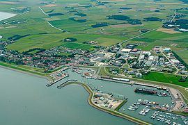
Oudeschild is the fishing harbour of the island. It is situated at the Wadden Sea dyke. Next to the harbour, the windmill Traanroeier marks the site of the Maritime and Beachcombers Museum, which exhibits an interesting collection of objects found on the beaches of Texel.
In the 17th century, the Dutch East India Company ships sailing from Amsterdam waited for favourable winds at the Reede of Texel, on the sea near Oudeschild.
Close to the village is the Hoge Berg (the so-called "High Mountain"), a 15 metre high hill. Near the Hoge Berg is the Russian's cemetery. Here lie the Georgians who died in their uprising in 1945.
In 2001, the town of Oudeschild had 1145 inhabitants, making it the fourth largest village in Texel. The built-up area of the town was 0.45 km², and contained 458 residences. The statistical area "Oudeschild", which also can include the peripheral parts of the village, as well as the surrounding countryside, has a population of around 1270.