
Elevation 1,210 m (3,970 ft) Area 42.5 km² Dialling code 0472 | Time zone CET (UTC+1) Local time Wednesday 2:31 PM Postal code 39030 | |
 | ||
Frazioni Pichlern (Colli in Pusteria) Demonym(s) German: TerentnerItalian: di Terento Weather 16°C, Wind E at 5 km/h, 29% Humidity Region Trentino-Alto Adige/South Tyrol | ||
Terenten
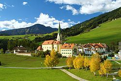
Terenten ( [ˈterɛntn̩]; Italian: Terento [teˈrento]) is a comune (municipality) in South Tyrol in northern Italy, located about 50 kilometres (31 mi) northeast of Bolzano.
Contents
- Terenten
- Map of 39030 Terento Province of Bolzano South Tyrol Italy
- Hotel und zimmercheck waldrast terenten s dtirol
- Geography
- Coat of arms
- Linguistic distribution
- References
Map of 39030 Terento Province of Bolzano - South Tyrol, Italy
Hotel und zimmercheck waldrast terenten s dtirol
Geography
As of November 30, 2010, it had a population of 1,719 and an area of 42.5 square kilometres (16.4 sq mi).
The municipality of Terenten contains the frazione (subdivision) Pichlern (Colli in Pusteria).
Terenten borders the following municipalities: Kiens, Mühlwald, and Vintl.
Coat-of-arms
The emblem represents a sable plough on gules background; it is the symbol of the local agriculture. The arms were granted in 1969.
Linguistic distribution
According to the 2011 census, 99.40% of the population speak German, 0.54% Italian and 0.06% Ladin as first language.
References
Terenten Wikipedia(Text) CC BY-SA