
Length 15 km (9.3 mi) | Elevation 2,430 m (7,970 ft) Mountains Raucheck | |
 | ||
Similar Alps, Eisriesenwelt, Hochkönig, Salzkammergut Mountains, Hohenwerfen Castle | ||
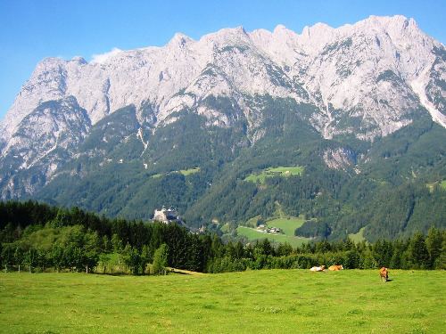
The Tennen Mountains (German: Tennengebirge) is a small, but rugged, mountain range in the Northern Limestone Alps, which lies in front of the Eastern Alps for its entire length. It is a very heavily karstified high plateau, about 60 km² in area, with many caves. The range is located in Austria in the district of Salzburg near Bischofshofen.
Contents
- Map of Tennen Mountains 5452 Pfarrwerfen Austria
- Extent and neighbouring rangesEdit
- Valley settlementsEdit
- SummitEdit
- GeologyEdit
- CavesEdit
- Walking and climbingEdit
- Long distance trailsEdit
- References
Map of Tennen Mountains, 5452 Pfarrwerfen, Austria
Some 37 square kilometres of the Tennen plateau are above the 2,000 metre line and that part of the range within the state of Salzburg was turned into a nature reserve in 1982.
Extent and neighbouring rangesEdit
The outline of the Tennen range is formed:
Valley settlementsEdit
SummitEdit
The highest mountains in the Tennen are Raucheck (2,430 m (AA)) in the west and Bleikogel (2,412 m (AA)) in the east. The highest points all rise on the southern edge of the plateau, which falls away to the north. The most important peaks are:
GeologyEdit
The Tennen is a heavily karstified massif, composed mainly of Dachstein limestone lying on a foundation of Ramsau dolomite.
Its southern foothills, along the line Lungötz–Werfenweng–Werfen, belong to an imbricate zone (Schuppenzone). This zone, made of Werfen Formation from the Lower Triassic and middle triadic dolomites (Anisian, Ladinian), is called the Werfen-St.-Martin Schuppen Zone.
CavesEdit
There are numerous caves in the Tennen Mountains.
The Tennen Mountains are a preferred research region for the State Cave Research Association in Salzburg, which collects and publishes results of its research. New caves are continually being found, but even old, well-known caves sometimes reveal new secrets.
Knowledge of the caves, and the routes that water takes through them, is important, particularly in terms of future water supply for the population and the protection of water resources.
Walking and climbingEdit
Being a high plateau, the Tennen has numerous trails for the Alpine hiker. However, walkers need to be aware of the lack of water in the karst terrain and the dangers of getting lost in mist or fog. Alpine experience and a good level of fitness are basic pre-requisites, even though there are many mountain huts available. The precipices on the edge of the plateau offer the climber a wide scope of climbing options. The faces on the southern edge of the range, especially around the Werfener Hut and above Dr. Heinrich Hackel Hut are very popular due to their easy accessibility. In winter there are various ski touring routes, mainly crossing the plateau, but also extreme ski routes in some places.
Long distance trailsEdit
The European long-distance trail E4/North Alpine Way 01/Via Alpina (Violet Trail Stage A34/35) runs through the southern Tennen, from Lungötz to Werfen via the Dr. Heinrich Hackel Hut.
In addition Salzburg's Arno Way runs along the west of the group (Section 6 Kalkberge Ost, Stage 52 Annaberg Laufener Hut and 53 to Abtenau).