
Settlements 41 Time zone CET (UTC+1) Local time Saturday 8:50 AM | Elevation 526 m (1,726 ft) Area 628 km² Team FK Radnik Surdulica | |
 | ||
Weather 10°C, Wind SE at 5 km/h, 66% Humidity | ||
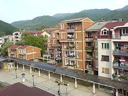
Surdulica (Serbian Cyrillic: Сурдулица) is a town and municipality located in the Pčinja District of southern Serbia. The population of the town is 11,400, while the municipality has 20,319 inhabitants.
Contents
- Map of Surdulica Serbia
- Geography
- History
- NATO bombing
- Education
- Settlements
- Demographics
- Ethnic groups
- References
Map of Surdulica, Serbia
Geography
The town stands at 480 m above sea level; it is surrounded by mountains to the north by Čemernik and to the south by Vardenik; the highest peak Strešer stands at 1875 meters high. Some twenty kilometres along the river Vrla and up the mountains there is a highland called Vlasina. In the 1950s, a man made dam created a lake called Vlasinsko Jezero (Vlasina Lake) which is famous for its peat floating islands which were harvested by local farmers. The highland of Vlasina is unique natural reserve with rich wildlife in particular the many rare species of migrating birds that use this unique place as a stop on their migrating way north or south. The lake is rich with fish and is one of largest reservoirs of clean water in that part of the country. The surrounding soil is lush and green resembling the Devon Downs or Argentine pampas. It presents great potential for cattle breeding and dairy production. It has distinct four seasons with long snowy winters and brief hot summers. There are also two streams running from the mountains and joining at the town of Surdulica. This is where the Romanovce River joins the Vrla River on their way to South Morava and thence to the Danube and the Black Sea.
History
Historically, the town by its modern name was first mentioned in texts from 1530 by Benedict Kuripešić. Following the revolutions of Serbia and the last Turks out of the town in 1877, it soon started to grow and develop in the hands of the independent nation of Serbia. Today, it is an industrial town with beautiful nature and plenty of wildlife.
From 1929 to 1941, Surdulica was part of the Vardar Banovina of the Kingdom of Yugoslavia.
During World War I, 2,000–3,000 men were massacred by Bulgarian forces in the town.
NATO bombing
NATO spokesman Jamie Shea commented that on April 27, 1999, during the NATO airstrikes against Yugoslavia, one NATO aircraft bombed a "small residential area" in Surdulica. Shea said that one bomb was "accidentally" released during an attack over an army barracks and stated repeatedly that NATO was doing "everything" to avoid civilian casualties. He claimed that, "technology is not perfect and never will be" and repeated that the strike was "accidental". However, eleven missiles in total were fired on Surdulica, injuring over three hundred civilians. Another twenty civilians were killed as a result of this attack, twelve of whom were little children. Eighteen houses in all were destroyed with another 500 homes were left permanently unsuitable for residing in.
Education
There are two primary schools in the town of Surdulica - Vuk Karadžić and Jovan Jovanović Zmaj, and several schools in the villages around the town. There are three secondary schools: Svetozar Marković Gimnazija (Grammar School), Josif Pančić School of Agriculture and a technical college, Nikola Tesla. In line with falling population in the municipality of Surdulica the number of high school students is also falling.
Settlements
Aside from the town of Surdulica, the municipality includes the following settlements:
Demographics
According to the 2011 census results, the municipality of Surdulica has a population of 20,319 inhabitants.
Ethnic groups
the ethnic composition of the municipality of Surdulica: