
Length 295 km | Discharge 100 m³/s | |
 | ||
Basin size 15,469 km (5,973 sq mi) | ||
South Morava or in the past Bulgarian Morava (Serbian and Macedonian: Јужна Морава, Serbian Latin: Južna Morava; [jûːʒnaː mɔ̝̌rav̞a]; Albanian: Lumi Morava; Bulgarian: Българска Морава, Balgarska Morava) is a river in eastern Kosovo and in southern Serbia, which represents the shorter headwater of Great Morava. Today, it is 295 km long. It flows generally in the south to north direction, from Macedonian border to Kosovo and onwards to Central Serbia, where it meets West Morava at Stalać, to create Great Morava.
Contents
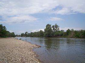
Map of Southern Morava, Serbia
Geography
South Morava belongs to the Black Sea drainage basin, and its own drainage area is 15,469 km², out of which 1,237 is in Bulgaria (through its right tributary Nišava). Its average discharge at the mouth is 100 m³/s and it is not navigable.
South Morava has a composite valley, which means it consists of series of gorges and valleys in this order: Gnjilane valley – Končulj gorge – Vranje valley – Grdelica gorge – Leskovac valley – Niš valley – Aleksinac valley – Stalać gorge. After breaking through the last, Stalać gorge, it meets West Morava.
In macro-geological point of view, South Morava connects Aegean basin with Pannonian basin. This creates a phenomenon named apparent flow inversion, because it seems that river from one lowland climbs up the mountains and then flows into another lowland. The point connecting these two large geological basins is Grdelica gorge (Serbian: Grdelička klisura/Грделичка клисура), but the bottom of the gorge, where the river flows, is much lower than the mountains surrounding it, so the river flows normally.
South Morava used to be 318 km long and represented longer and natural (flowing in the same direction) headwater of Great Morava. Causing severe floods in history, meandering river has been shortened by almost 30 km until today, so it became shorter than West Morava. However, West Morava has always had bigger discharge.
Areas in southern Serbia where South Morava flows have been almost completely deforested, which causes one of the most severe cases of erosion in the Balkans. As a result of this, the river brings large amount of materials to the Great Morava, filling and elevating its river bed, which helps the huge floods of its daughter river.
Tributaries
South Morava has 157 tributaries. The most important left ones are: Jablanica, Veternica, Pusta reka and Toplica. Right tributaries are: Vrla, Vlasina, Nišava (the longest) and Sokobanjska Moravica.
Economy
South Morava has a significant potential for electricity production, but this has not been used at all. Huge hydroelectrical system has been constructed in its drainage basin, though (Vlasina- Vrla I-IV power stations).
To a certain extent, its waters are used for irrigation.
The most important role river valley has in transportation. It is the natural route for both railway and highway Belgrade–Skopje–Thessaloniki. It is part of the Pan-European corridor X, and the route of E75 Highway.