
 | ||
Subi Reef, also known as Zhubi Reef (Chinese: 渚碧礁; pinyin: Zhǔbì Jiāo; Tagalog: Zamora; Vietnamese: đá Xu Bi) is a reef in the Spratly Islands of the South China Sea located 26 km (16 mi) southwest of Philippine-occupied Thitu Island. It is occupied by China, and claimed by Taiwan, Vietnam, and the Philippines. It currently falls under the jurisdiction of Nansha islands, Sansha city, Hainan province, China.
Contents
- Map of Subi Reef
- Topography and features
- Legal issues
- Environmental issues
- Territorial disputes
- References
Map of Subi Reef
Topography and features
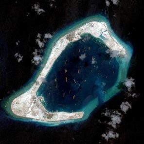
The atoll measures 5.7 km along its longer southwest-northeast axis, and is up to 3.5 km wide. Its total area including the lagoon and rim of the reef measures 16 km², and the lagoon is up to 22 meters deep.
Naturally above water only at low tide, the reef surrounds a lagoon. The People's Republic of China has constructed a 4-story building, a weather observation station with doppler weather radar, wharfs, and a helipad in the area. A buoyed channel guides ships to the inner lagoon which is 3.7 kilometers in diameter.
On 12 July 2016, the tribunal of the Permanent Court of Arbitration confirmed that Subi Reef is, or in their natural condition was, exposed at low tide and submerged at high tide and are, accordingly low-tide elevations that do not generate entitlement to a territorial sea, exclusive economic zone or continental shelf.
Legal issues
As the Subi Reef is under the water, it is considered by the Third United Nations Conference on the Law of the Sea (UNCLOS III) as "sea bed" in "international waters". Although the PRC had ratified a limited UNCLOS III not allowing innocent passage of war ships, according the UNCLOS III, features built on the sea bed cannot have territorial waters.
Environmental issues
The PRC has ratified UNCLOS III; the convention establishes general obligations for safeguarding the marine environment and protecting freedom of scientific research on the high seas, and also creates an innovative legal regime for controlling mineral resource exploitation in deep seabed areas beyond national jurisdiction, through an International Seabed Authority and the Common heritage of mankind principle.
Territorial disputes
The reef is occupied and controlled by China (PRC), with a 2014 estimate of 200 troops stationed there, and claimed by Taiwan (ROC), the Philippines, and Vietnam. In July 2012, a large fleet of 30 Chinese fishing vessels arrived at the reef from Hainan.
In April 2015, a Philippine Navy aircraft patrolling near the reef received "aggressive action" from a Chinese ship. Also in 2015, the USS Lassen sailed within 12 nautical miles (which if applicable is the territorial waters limit of the reef), prompting the Chinese Foreign Ministry to call the action a "provocation" and they vowed to keep building up in the South China Sea. As per the US Navy, this was a routine "freedom of navigation" exercise. Similar exercises are performed routinely about 12-28 times per year.
During 2014, the Chinese started reclaiming land at Subi Reef, and by the end of 2015 had developed it into an island of 3.95 square kilometres (1.53 sq mi), with a military base, a large harbour, and an airstrip of about 3,000 metres. In November 2015, two U.S. B-52 strategic bombers flew in airspace near the area. They were contacted by Chinese ground control, but were allowed to continue their mission undeterred. In April 2016 a new lighthouse 55 metres high commenced operations. A civilian test flight to new airport was conducted by a passenger jet of Hainan Airlines on July 13, 2016.