
Material Stone | Design Arch Opened 1832 Location Staines Number of spans 3 | |
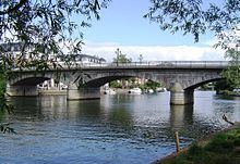 | ||
Height 19 feet 6 inches (5.94 m) Similar River Thames, Penton Hook Island, Penton Hook Lock, Staines railway station, Chertsey Bridge | ||
Staines Bridge is a road bridge running in a south-west to north-east direction across the River Thames in Surrey. It is on the modern A308 road and links the boroughs of Spelthorne and Runnymede at Staines and Egham Hythe.
Contents
Map of Staines Bridge, Staines TW18, UK
The bridge crosses the Thames on the reach between Penton Hook Lock and Bell Weir Lock, and is close to and upstream of the main mouth of the River Colne, a tributary. The bridge carries the Thames Path across the river.
History
In Roman times, Staines lay on the Devil's Highway, an important road connecting the provincial capital Londinium (London) with points west via Calleva Atrebatum (Silchester). The site's Latin name was Pontes ("The Bridges"), implying that there was more than one bridge. It is believed that these bridges traversed Church Island.
A wooden bridge was referenced as early as 1228, and required regular repair. It was put out of use during the Civil War. Under an act of 1791, a stone bridge was built a little way downstream of the old one, the latter being retained. The central arch of this bridge cracked almost immediately and a third bridge of iron was completed in 1803. This failed and a fourth bridge, also of iron was opened in 1807. The old wooden bridge, which had continued in service, was then pulled down. The fifth and present bridge with three arches in white granite was designed by George Rennie. Construction started in 1827, and it was opened in 1832.
From the 1940s until the 1970s this was a hotspot for summer holiday traffic jams due to many motorists heading from London towards the south-west. When the M3 and later the M25 bridges were constructed, the traffic was diverted away from the town.
In literature
In his Arthurian novel Enemy of God Bernard Cornwell sites an 11-arch stone bridge at Pontes/Staines. He attributes it 7 arches over the river with two on land at each end. A the Western end is a tower over the road from Calleva, which bears a plaque commemorating its building by Emperor Hadrian. At the Eastern end an earth-walled settlement.
Roman Road
The Roman Road does not have a popular name, but a straight line road route from Staines to London Wall can clearly be traced on modern maps via the A30, A315, A402 and Oxford Street. It passes through the modern towns of Hounslow, Brentford, Shepherds Bush and Holborn, interrupted only by a stretch of the District line between Gunnersbury and Turnham Green. The route west of Staines is less clear, because of subsequent agricultural land use, and possibly flood erosion.
The next Roman road clockwise out of London is Watling Street to Wroxeter (Viroconium) near Shrewsbury, and the next Roman road anti-clockwise is the confusingly named Stane Street to Chichester (Noviomagus Regnorum).