
- average 4.05 m/s (143 cu ft/s) | Discharge 4.05 m³/s | |
 | ||
- max 18.4 m/s (650 cu ft/s) 14 October 1993 | ||
The Colne is a river in England which is a tributary of the River Thames. Just over half its course is in south Hertfordshire. Downstream, the Colne is the boundary between Buckinghamshire (specifically the South Bucks district) and London (specifically the London Borough of Hillingdon) and finally between corners of Berkshire and Surrey. On leaving Hertfordshire, the watercourse splits off into several separate branches, a few of which rejoin it, and its main branch flows into the River Thames on the reach above Penton Hook Lock at Staines-upon-Thames.
Contents
- Route
- Eponymous settlements and indirect reference to the river within a district name
- Use of valley and river for navigation
- Structures
- Tributaries and distributaries
- References
Two further, artificial distributaries were constructed in the 1600-1750 period for aesthetic reasons for Hampton Court and for Syon Park which have been kept maintained, flowing through several London districts. Although their main purpose was not drinking water, these artificial streams can be likened to the New River in scale and in date. Crossing its route, viaducts and canals, such as the Grand Union Canal have been recognised for pioneering engineering during the Industrial Revolution.
Digging for gravel and clay along its lower course south of Rickmansworth has created a long belt of pits which have flooded to become lakes. Many of these are important habitats for wildlife and protected as nature reserves. The river, meadows and many once gravel-producing lakes form the Colne Valley regional park in total covering 43 square miles (110 km2).
Route
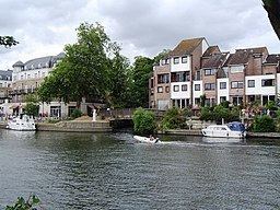
The Colne rises perennially from a subterranean river at a spring in North Mymms Park in Hertfordshire. Two occasionally dry tributaries: an unnamed brook and the Mimmshall Brook start 2.5 to 4 mi (4.0 to 6.4 km) from the source at golf courses in Barnet, at Borehamwood and in fields by Northaw Place, Northaw. This underground stretch under the old village centre of North Mymms runs for 1.1 mi (1.8 km) from swallow holes of the two brooks in the part of that parish named Water End. From the Water End Swallow Holes the Colne runs NW then SW, bounding central and residential Watford and Oxhey, also bounding Rickmansworth and Batchworth, then marking the border between Greater London and Buckinghamshire. After these conjoined settlements it turns south, its main direction, and passes between West Hyde, near Maple Cross, and Harefield, passes Denham Green then passes Uxbridge, where it parallels the Grand Union Canal and its distributary the Frays River which is joined later by the River Pinn between Cowley and Yiewsley on the Greater London side. The Colne Brook splits off as a distributary between New Denham and Uxbridge. After this, at West Drayton, the Frays River rejoins and the Wraysbury River and Duke of Northumberland's River divide off.
In its lower reaches, the river at Longford supplies water to the Longford River, a 12-mile (19 km) artificial channel created in 1610 for King Charles I to supply the water features in Bushy Park and the rectangular lakes in Hampton Court Park.
The Colne's drainage basin extends almost as far north again as the main stream of the river beginning in Hertfordshire: its tributaries, including the Gade, Ver and Misbourne, all extend well into the Chilterns. The Colne's drainage basin is bordered by a range of Thames tributaries to the east and west, including the Crane, Brent and Lea to the east and Wye to the west. To the north of Tring a modest ridge acts as a watershed, separating the Colne's drainage basin from that of the River Great Ouse, which flows north and east towards the Wash.
Eponymous settlements and indirect reference to the river within a district name
The villages of Colney Heath east of St Albans, London Colney south of St Albans, Colney Street (almost wholly a large business park) north of Radlett and Colnbrook between Slough and Heathrow take their name from the river. Three Rivers district covers an area of Hertfordshire named after the River Colne and its two tributary rivers which join the closest together, the River Chess and the River Gade.
Use of valley and river for navigation
Among early proposals to link the river to London was one in 1641 by Sir Edward Forde for a navigable canal, the main purpose of which seems to have been the supply of clean water, and two in 1766, for canals from Marylebone to the river at Uxbridge and another from Marylebone to West Drayton.
The river underwent considerable change in the 1790s, when the Grand Junction Canal (which became part of the Grand Union Canal in 1929) was routed along the valley and still takes the river channel for part of its course. Construction began from Brentford, where it used for 3 miles (4.8 km) the channel of the River Brent, and progressed westwards then northwards, with it reaching Uxbridge in November 1794. To reach the Midlands it continued along the river channel until its junction with the River Gade, which it ran parallel to, but did not take over the channel. The Slough Arm was built in 1882 which required three aqueducts to carry it close to its junction with the Grand Junction, to cross the Fray's River, the River Colne and the Colne Brook.
Between Croxley Green, where the River Gade joins the Colne, and Thorney/West Drayton, below the Slough Arm, the river channels thread their way between many large lakes, some of which were once watercress beds, some chalk pits, and some of which were the result of brickmaking, an industry that developed over several miles of the valley after 1800, when the Grand Junction Canal company advertised the presence of good brick earth, discovered during the construction of the canal.
Structures
There are two London Coal Duty markers beside the river, which mark points at which duty became payable on coal entering the London area. The first is on the north side of the river in Colney Heath Local Nature Reserve, and is a square-section cast iron pillar made by Henry Grissell at his Regents Canal ironworks and erected in 1861 or 1862. It is 5 feet (1.5 m) high and is painted white. The second is a stone obelisk, 13 feet (4.0 m) high, with a square base, which was erected at Colne Bridge in 1861. It was moved from its original position to the other side of the river in 1984, when it was repaired by Watford Borough Council. It is close to a five-arched railway viaduct, which was built in 1837 to carry the London to Birmingham Railway over the river. Each of the arches spans around 40 feet (12 m) and is 45 feet (14 m) high. The structure was designed by Robert Stephenson, and is grade II listed.
At London Colney there is a seven-arched brick bridge which carries Barnet Road over the river. It dates from 1774, and is called Telford's Bridge, although it is not thought to have been designed by Thomas Telford. It was modified in the 20th century, when parapets and railings were added.
There was a long-running dispute over water levels in the Batchford area, following construction of the Grand Junction Canal, which were resolved in 1825, when an 8.2-foot (2.5 m) obelisk was erected in a pond, to act as a water gauge. The obelisk records the agreement made between the canal company, John Dickinson who was the miller at Batchworth Mill, and R. Williams of Moor Park, who was the landowner.
Tributaries and distributaries
From its mouth on the Thames to its source, the Colne's main tributaries and distributaries are: