
Elevation 735 m (2,411 ft) Area 63.1 km² | Time zone CET (UTC+1) Local time Saturday 4:43 AM Postal code 39010 | |
 | ||
Region Trentino-Alto Adige/Südtirol Demonym(s) German: PankrazerItalian: di San Pancrazio Weather 5°C, Wind NW at 6 km/h, 67% Humidity | ||
Harlem shake charlys pub 13 st pankraz
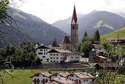
Sankt Pankraz ( [saŋkt ˈpaŋkrats]; Italian: San Pancrazio [sam paŋˈkrattsjo]) is a comune (municipality) in South Tyrol in northern Italy, located about 20 kilometres (12 mi) northwest of the city of Bolzano.
Contents
- Harlem shake charlys pub 13 st pankraz
- Map of 39010 St Pankraz Province of Bolzano South Tyrol Italy
- 40 jahre freundschaft 1 mai 2009 musikkapelle st pankraz musikverein ohmden
- Geography
- Coat of arms
- Linguistic distribution
- References
Map of 39010 St. Pankraz, Province of Bolzano - South Tyrol, Italy
40 jahre freundschaft 1 mai 2009 musikkapelle st pankraz musikverein ohmden
Geography
As of 30 November 2010, it had a population of 1,589 and an area of 63.1 square kilometres (24.4 sq mi).
Sankt Pankraz borders the following municipalities: Lana, Laurein, Naturns, Unsere Liebe Frau im Walde-St. Felix, Tisens, Ulten, and Castelfondo.
Coat-of-arms
The emblem represents a tower with battlements, with a pavilion azure roof, surrounded by a wall above a vert hill with two fir-trees on each side on argent. The castle tower corresponds to the Eschenloch Castle built in the twelfth century by the Counts of Ulten. The emblem was adopted in 1968.
Linguistic distribution
According to the 2011 census, 98.84% of the population spoke German, 0.96% Italian and 0.19% Ladin as their first language.