
Country United States County Franklin Organized (town) 1785 Elevation 61 m Zip code 05478 Local time Friday 8:34 AM | State Vermont Settled 1783 Incorporated (city) 1902 Area 40.1 km² Population 6,918 (2010) Area code 802 | |
 | ||
Weather 2°C, Wind SE at 6 km/h, 60% Humidity | ||
St. Albans City is the county seat of Franklin County, Vermont, in the United States. At the 2010 census, the city population was 6,918. St Albans City is surrounded by "St. Albans Town", which is incorporated separately from the city of St. Albans. The city and county are part of the Burlington metropolitan area, although the city is in Franklin County, north of the metro area's most populous county, Chittenden County.
Contents
- Map of St Albans City VT USA
- History
- Culture
- Geography
- Demographics
- Government
- Personal income
- Industry
- Health care
- Railways
- Education
- References
Map of St Albans City, VT, USA
History
One of the New Hampshire grants, St. Albans was chartered by Colonial Governor Benning Wentworth on August 17, 1763 to Stephen Pomeroy and 63 others. Named after St. Albans, Hertfordshire, England, it was first settled during the Revolution by Jesse Welden. The war delayed further settlement until 1785, when many others began to arrive. Farmers found the rich, dark loam suitable for cultivation, as well as for the raising of cattle, horses and sheep. Butter and cheese were produced in great quantities. St. Albans also became known as "Railroad City," home to a major depot, operations center and repair shop of the Vermont and Canada Railroad. When the village was incorporated in 1859, it had an iron foundry, a manufacturer of freight cars, and a large number of mechanic shops.
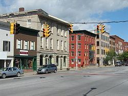
The northernmost engagement of the Civil War, known as the St. Albans Raid, occurred here on October 19, 1864. In 1902, the City of St. Albans was incorporated, comprising two square miles (518 hectares) within the town of St. Albans. Today it is a tourist destination noted for its Victorian and Craftsman style architecture built during the railroad era, when over 200 trains a day passed through. St. Albans is a research target for genealogists, as European immigrants heading for the United States would sometimes land at Halifax, Nova Scotia or Montreal, then take a train through the border crossing here. The National Archives (NARA) lists for St. Albans cover the period 1895–1954.
Culture
In late April St. Albans hosts the annual Vermont Maple Festival. The festival includes various food-related contests, as well as the Sap Run, a footrace from Swanton, 8.2 miles (13.2 km) to the north. It is home to the Vermont Voltage, a semi-professional men's soccer team.
Geography
According to the United States Census Bureau, the city has a total area of 2.0 square miles (5.3 km2), all land. The city is surrounded by the town of St. Albans, with its lush farmland across gently rolling hills. The city is drained by Stevens Brook.
St. Albans is crossed by Interstate 89, U.S. Route 7, as well as Vermont Route 36, 38, 104 and 105. It is about 15 miles (24 km) from Vermont's border with Quebec.
Demographics
At the 2010 census, there were 6,918 people. In the 2000 census there were 7,650 people, 3,235 households and 1,937 families residing in the city. The population density was 3,768.2 per square mile (1,455.0/km2). There were 3,376 housing units at an average density of 1,662.9 per square mile (642.1/km2). The racial makeup of the city was 95.87% White, 0.39% Black or African American, 1.20% Native American, 0.35% Asian, 0.03% Pacific Islander, 0.45% from other races, and 1.70% from two or more races. 0.90% of the population were Hispanic or Latino of any race.
There were 3,235 households of which 31.6% had children under the age of 18 living with them, 43.6% were married couples living together, 12.1% had a female householder with no husband present, and 40.1% were non-families. 31.4% of all households were made up of individuals and 12.6% had someone living alone who was 65 years of age or older. The average household size was 2.35 and the average family size was 2.97.
Age distribution was 25.6% under the age of 18, 8.3% from 18 to 24, 31.8% from 25 to 44, 20.3% from 45 to 64, and 14.0% who were 65 years of age or older. The median age was 35 years. For every 100 females there were 91.6 males. For every 100 females age 18 and over, there were 86.2 males.
Government
St. Albans is governed via a mayor, a city manager and city council. The city council consists of six members, each elected from an individual ward. The mayor is elected by citywide vote.
Personal income
In the 2010 census, the median household income was $37,221, and the median family income was $44,286. Males had a median income of $31,340 versus $23,262 for females. The city's per capita income was $17,853. About 8.5% of families and 9.6% of the population were below the poverty line, including 9.2% of those under age 18 and 11.9% of those age 65 or over.
Industry
The USCIS has a service center in St. Albans. The city also has a thriving industrial park with manufacturing branches for companies including Ben & Jerry's, Mylan, NECR, Barry Callebaut, and others.
Health care
The Northwestern Medical Center is a hospital serving the city and the Franklin County area.
Railways
Saint Albans is the northern terminus of the Vermonter, an all-coach train operated by Amtrak, the national passenger rail system. The train operates daily between Saint Albans and Washington, D.C.
The train formerly continued from Saint Albans to Montreal and was named the Montrealer, but that connection was discontinued.
Education
St. Albans is home to St. Albans City School, an elementary school for students in kindergarten through eighth grade, and Bellows Free Academy, St. Albans, a public high school serving students from many towns in the southern half of Franklin Country.