
- elevation 1,293 ft (394 m) Length 179 km | - elevation 1,994 ft (608 m) Discharge 225 m³/s Basin area 15,592 km² | |
 | ||
- average 7,946 cu ft/s (225 m/s) - max 49,700 cu ft/s (1,407 m/s) Bridges Monroe Street Bridge, Spokane River Bridge at Long Lake Dam | ||
The spokane river 1970 a film by robert l pryor
The Spokane River is a tributary of the Columbia River, approximately 111 miles (179 km) long, in northern Idaho and eastern Washington in the United States. It drains a low mountainous area east of the Columbia, passing through the Spokane Valley and the city of Spokane, Washington.
Contents
- The spokane river 1970 a film by robert l pryor
- Map of Spokane RIver Washington USA
- Fantastic spokane riverfront park spokane washington
- DescriptionEdit
- Human useEdit
- PollutionEdit
- Fish habitatEdit
- References
Map of Spokane RIver, Washington, USA
Fantastic spokane riverfront park spokane washington
DescriptionEdit
The Spokane River drains the northern part of Lake Coeur d'Alene in the Idaho Panhandle, emptying into the Columbia River at Franklin D. Roosevelt Lake, approximately 180 km downstream.
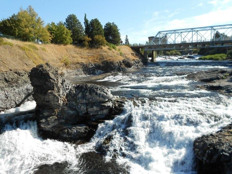
From Lake Coeur d'Alene, the Spokane River traverses the Rathdrum Prairie until reaching Post Falls, Idaho where it passes over a dam, and a natural 40-foot waterfall. Continuing westward it passes over 6 more dams, three of which (Upriver Dam, Upper Falls Dam, Monroe Street Dam) are located in the city of Spokane. In Spokane, it flows over the Spokane Falls, which are located in the heart of Downtown Spokane, approximately one third of the way down the river's length. About a mile later, the river receives Latah Creek from the southeast. Soon afterwards, it is met from the northeast by the Little Spokane River, on the western edge of the city of Spokane. It flows in a zigzag course along the southern edge of the Selkirk Mountains, forming the southern boundary of the Spokane Indian Reservation, where it is impounded by the Long Lake Dam to form Long Lake, a 15 mi (24 km) reservoir. It joins Franklin D. Roosevelt Lake on the Columbia from the east at Miles. The site of historic Fort Spokane is located at the confluence of the Spokane and Columbia rivers.
The Spokane River's entire drainage basin is about 6,240 square miles (16,200 km2) large, of which 3,840 square miles (9,900 km2) are above Post Falls Dam at the outlet of Coeur d'Alene Lake. Its mean annual discharge is 7,946 cubic feet per second (225 m3/s).
Human useEdit
Until the 18th century, the Coeur d'Alene (Schḭtsu'umsh) and Spokane Native Americans (along with other Salish peoples) used to live and travel along the banks of the Spokane River. In 1807, David Thompson was the first European to cross the Rocky Mountains and explore the area.
Today, the metropolitan area of the city of Spokane, Washington (population 213,272) is the largest human settlement on the banks of the Spokane River. The metropolitan areas of Coeur d'Alene and Post Falls, Idaho (pop. 200,000) are also seated alongside the river. The Spokane River and Lake Coeur d'Alene area the primary sources of recharge for the Spokane aquifer, which is the primary source of drinking water for each of these settlements.
PollutionEdit
The Spokane River contains some of the highest concentrations of heavy metals of any river in the state, resulting from pollution coming from Lake Coeur D'Alene and traveling from the Bunker Hill Mine and Smelting Complex Superfund Site.
Spokane's sewage treatment facilities empty their outflow into the Spokane River. In 1889, Spokane built a sewage system that dumped raw sewage directly into the river, which was visibly noticeable by 1920. In 1957 a primary treatment facility was installed; however, this was soon deemed inadequate by the Washington State Department of Ecology. This led to the construction of a more advanced treatment plant that utilized chemical precipitation technology, which was connected in 1975, and operational by 1977.
Fish habitatEdit
After the Northern Pacific Railway lines arrived in Spokane in 1882, there was rapid growth in milling operations along the river. Many of these mills required dams to provide power for their machinery. As a result of the dams blocking the river, salmon populations in the Spokane plummeted, leading to complaints from many of the people living upstream. After the construction of Little Falls Dam in 1910 by Washington Water Power blocked upstream passage, the river's salmon populations disappeared completely.
Steelhead were also abundant on the Spokane River, prior to pollution and the construction of the dams. Today, the Spokane River system is one of the two largest unoccupied stretches of steelhead habitat within their former range.
Today, the Spokane River supports populations of rainbow trout, northern pikeminnow, and Bridgelip Suckers (Catostomus columbianus), as well as several non-native species. Many of the remaining fish, however, are not suitable for human consumption due to the chemical pollution in the river, with signs alongside the river warning that the fish are contaminated with PCBs.