
 | ||
Space-oblique Mercator projection is a map projection.
Contents
History
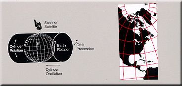
The space-oblique Mercator projection (SOM) was developed by John P. Snyder, Alden Partridge Colvocoresses and John L. Junkins in 1976. Snyder had an interest in maps, originating back to his childhood and he regularly attended cartography conferences while on vacation. When the United States Geological Survey (USGS) needed to develop a system for reducing the amount of distortion caused when satellite pictures of the ellipsoidal Earth were printed on a flat page, they appealed for help at one such conference. Snyder worked on the problem armed with his newly purchased pocket calculator and devised the mathematical formulas needed to solve the problem. He submitted these to the USGS at no charge, starting off a new career at USGS. His formulas were used to produce maps from Landsat 4 images launched in the summer of 1978.
Projection description
The space-oblique Mercator projection provides continual conformal mapping of the swath sensed by a satellite. Scale is true along the ground track, varying 0.01 percent within the normal sensing range of the satellite. Conformality is correct within a few parts per million for the sensing range. Distortion is essentially constant along lines of constant distance parallel to the ground track. SOM is the only projection presented that takes the rotation of Earth into account.
Equations
The forward equations for the Space Oblique Mercator projection for the sphere are as follows: