
Length 70 mi (110 km) Orogeny Grenville orogeny Types of rock Granite, Gneiss | Elevation 2,150 ft (660 m) Width 12 mi (19 km) Parent range Blue Ridge Mountains | |
 | ||
Type of rock Granite, gneiss and limestone Similar Washington Monument State Park, Gathland State Park, Blue Ridge Mountains, Crampton's Gap, Catoctin Mountain | ||
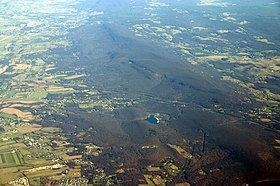
South Mountain is the northern extension of the Blue Ridge Mountain range in Maryland and Pennsylvania. From the Potomac River near Knoxville, Maryland, in the south, to Dillsburg, Pennsylvania, in the north, the 70-mile-long (110 km) range separates the Hagerstown and Cumberland valleys from the Piedmont regions of the two states. The Appalachian National Scenic Trail follows the crest of the mountain through Maryland and a portion of Pennsylvania.
Contents
- Map of South Mountain Highfield Cascade MD 17268 USA
- GeographyEdit
- MarylandEdit
- PennsylvaniaEdit
- ConservationEdit
- HistoryEdit
- References
Map of South Mountain, Highfield-Cascade, MD 17268, USA
GeographyEdit
South Mountain begins at the Potomac River as a low, narrow ridge, barely one mile wide and only 1,200 feet (370 m) above sea level at its crest. South of the Potomac River in Virginia, the ridge continues as Short Hill Mountain for about 12 miles (19 km) before subsiding near the town of Hillsboro. South Mountain in Maryland gradually grows higher and wider towards the north. Near the Pennsylvania border, the mountain merges with the hills of the parallel Catoctin Mountain range to the east and becomes more like a low mountain range than a single crest. North of U.S. Route 30 in Pennsylvania, the South Mountain highlands reach their greatest width, over 12 miles (19 km), and several summits top 2,000 feet (610 m). The mountain then turns more to the east and becomes a series of small rocky hills between Mount Holly Springs and the northeastern end of the mountain at Dillsburg.
MarylandEdit
From south to north:
PennsylvaniaEdit
From south to north, then east:
MarylandEdit
From south to north:
PennsylvaniaEdit
From south to north:
MarylandEdit
From south to north:
PennsylvaniaEdit
From south to north:
ConservationEdit
In Pennsylvania, the region surrounding is the focus of a Conservation Landscape Initiative, led by the Pennsylvania Department of Conservation and Natural Resources (DCNR) and the Appalachian Trail Conservancy. The initiative is organized as South Mountain Partnership, which involves other organizations, government, business, and community members.
HistoryEdit
The Battle of South Mountain was fought on the mountain at Crampton's, Fox and Turner's gaps during the Maryland Campaign of the American Civil War in 1862. In 1863, military engagements of the Gettysburg Campaign on the mountain range included the Fight at Monterey Pass near the Mason–Dixon Line.