
Easiest route drive Prominence 445 m | Elevation 655 m | |
 | ||
Similar Lambs Knoll, Clarks Knob, Cross Mountain, Furnace Mountain, Short Hill Mountain | ||
High rock road pen mar md from the top of the quirauk mountain while you were sleeping
Quirauk Mountain is the highest point on South Mountain. The 2,145-foot (654 m) peak is located in northeastern Washington County, Maryland. It lies just southwest of Fort Ritchie Military Reservation in the village of Cascade and about 1/2 mile southeast of the community of Blue Mountain. The Appalachian Trail and South Mountain State Park are about 1/2 mile to the west of the mountain's summit.
Contents
- High rock road pen mar md from the top of the quirauk mountain while you were sleeping
- Map of Quirauk Mountain Highfield Cascade MD 21719 USA
- BackgroundEdit
- References
Map of Quirauk Mountain, Highfield-Cascade, MD 21719, USA
BackgroundEdit
On the summit is a broadcast tower for radio stations WETH-FM and WAYZ-FM (in Hagerstown) and "Site C", a radio communication outpost of the Alternate Joint Communications Center, a United States Department of Defense emergency relocation site near Blue Ridge Summit, Pennsylvania. There is a fenced-in area of the mountaintop that is federal property and thus a restricted area. Quirauk Mountain's broadcast tower was formerly used by radio stations WJEJ-AM and WWMD-FM. A fire lookout tower also used to occupy the summit.
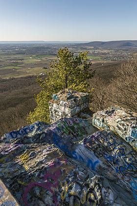
About 1/2 mile to the west-southwest of the summit is High Rock (on the Appalachian Trail), which provides an excellent view of the surrounding countryside