
 | ||
South Central Siberia, also known as Southern Siberia, is a region of Russian Siberia west of Lake Baikal and north of the Altai Mountains. In some contexts, Southern Siberia may also include parts of Central Asian countries that neighbour Russia.
Contents
- The Four Corners
- South Altai Republic
- North Abakans and Kuznetsk Alatau
- West Kuznetsk Depression
- East Minusinsk Depression
- Southeast Tuva
- Also
- Relevant Literature
- References
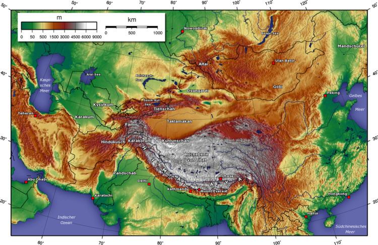
The map at right shows the Kemerovo Oblast which runs from the Altai Republic in the south to the Kuznetsk Alatau Mountains in the north. It is a belt of mountains with steppe on both sides. Since this line makes a convenient landmark, we will look first at the Altai, then the Kuznetsk Alatau and then the west and east sides of the line. The line separates the upper basins of the Ob and Yenisei Rivers.
The Four Corners
At approximately 49°8′8″N 87°33′46″E, the borders of Russia, China, Mongolia and Kazakhstan form an "X" shape in the Altai Mountains. Mongolia and Kazakhstan are kept separate by a 40km stretch of the Sino-Russian border between the Altai Republic, a federal subject of Russia, and Altay Prefecture in the Xinjiang Uyghur Autonomous Region of China. To the east, Tavan Bogd Uul in Bayan-Ölgii Province, Mongolia, marks the end of the Sino-Russian border. To the west, is Kazakhstan's East Kazakhstan Province.
Only the Altai mountains on the Russian side of the border has been designated a UNESCO world heritage site.
South: Altai Republic
At the top of the X is the Altai Republic (not to be confused with the Altai Krai to the northwest). It contains the central knot to the Altai Mountains. The area is very mountainous and still has few good roads. It was inhabited by various Turkic groups who gradually became the Altay people. As the surrounding steppes filled with Russians, many of the lowland Turks were Russified or retreated to the mountains. It only came under definitive Russian control in the 1860s. The M52 highway (Russia) runs northwest from here.
North: Abakans and Kuznetsk Alatau
North of the Altai is the 400 km projection of forested mountains which bends slightly to the west at the tip. It is called the Abakan Range in the south and Kuznetsk Alatau in the north. The name (Kuznets=blacksmith) comes from the 'Blacksmith Tatars' or Shors, who were notable metal workers. The Russians reached the area as early as 1618. The Abakans, Kuznetsk Alatau and the Kuznetsk form the Kemerovo Oblast with its mostly Russian population.
West: Kuznetsk Depression
The Salair Ridge extends northwest from the Abakans forming a sort to thumb. Between the 'thumb' and the 'fingers' is the steppe of the Kuznetsk Depression, which contains the large Kuznetsk Basin coal fields. Tom River drains the east side of the basin and joins the Ob River north of Tomsk. The town of Novokuznetsk was founded in 1618
To the west of this is the agricultural steppe of the Altai Krai with its Russian population. Here Katun River and Biya Rivers join to form the Ob River.
Further west, between the Ob and Irtysh River are the Baraba steppe in the north and the Kalunda Steppe in the south.
East: Minusinsk Depression
To the east, between the Kuznetsk Alatau and the Sayans, is the steppe of the Minusinsk Depression. The Yenisei River flows north through its center. The Abakan River flows from the base of the depression north and slightly east to the Yenisei at Abakan town, near where a (name?) river comes in from the east. Minusinsk town is a few miles east of Abakan. The Chulym River (Ob River) starts in the northwest corner of the depression, arcs into the Taiga north of the Alatau and joins the Ob River. Between the mountains and the Yenisei is the Khakassia republic. East of the river is the southern tip of Krasnoyarsk Krai. This area was a centre of the Afanasevo culture, a suggested homeland for the Tocharians. Later it was the home of the Yenisei Kirghiz, who gave their name to the Kirgiz further south. The Khakas of Khakassia may be their descendents.
East of Minusinsk are the Sayan Mountains which form a twisted 'T'. The Eastern Sayans run from the upper Minusinsk Depression about 650 km east and slightly south almost to the tip of Lake Baikal. The Western Sayans run northeast from the Altai about 600 km and meet the Eastern Sayans near their western end, separating the Minusinsk Depression from Tuva.
North of the Sayans is mostly permafrost and Taiga with a few patches of steppe around Lake Baikal. Here the proper steppe is south of the border in Mongolia.
Southeast: Tuva
East of the Altai and southeast of Minusinsk is Tuva. Tuva is bounded on the south by the Tannu-Ola Mountains, which separate it from the Mongolian Great Lakes Depression, on the west by the Altai, on the northwest by the Western Sayans which separate it from the Minusinsk Depression, on the north by the Eastern Sayans and on the east by (name?) mountains on the Mongolian border.
The core area is the Tuva Depression, where Kyzyl is located, the capital city of the Tuva Republic. The Yenisei River flows west here and then breaks through the Western Sayans in a long narrow gorge which contains the Sayano-Shushenskaya Dam north of the Tuva border. Tuva is somewhat boot-shaped facing west. The shank of the boot is separated from the Tuva Depression by the (name?) mountains. Tuva was traditionally part of Mongolia, and only passed to the Soviet Union—Russia in the 20th century.
Also
Large Towns:
Tomsk is about 50 km north of the Kuznetsk Alatau.
Novosibirsk is about 100 km northwest of the Salair 'thumb' on the Ob River.
Krasnoyarsk is about 100 km north of the Minusinsk Depression on the Yenesei.
The Trans-Siberian Railway runs from Novosibirsk to Krasnoyarsk. There is a parallel line to the south.
Forest and Steppe: The area to the west is steppe or forest-steppe. The steppe curves around north of the Kuznetsk Alatau into the Minusinsk Depression. The land to the north and east is Taiga.
The Russians first entered the area about 1620. Seeking furs, they stayed in the forest area to the north. Massive peasant colonization of the steppe area only began after about 1860.
Orphan Articles: The following places are in the area and need to have their exact location established: Ukok Plateau Saylyugem Mountains Lake Kanas Darkhad valley Pazyryk Valley