
Prominence c. 338 m (1109 ft) Pronunciation /bɑːˈruːl/ OS grid SC257759 Elevation 483 m | Topo map OS Landranger 95 Listing Marilyn | |
 | ||
Similar North Barrule, Slieau Freoaghane, Snaefell, Mull Hill, Beinn‑y‑Phott | ||
South barrule descent isle of man mountain biking
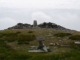
The South Barrule (Manx: Baarool Jiass) is the highest hill in the south of the Isle of Man. It has the remains of a fort on its summit, which is traditionally the home of the Manx god of the sea Mannanan beg mac y Leir. The hill is largely surrounded by conifer plantations. On the south western slope of the hill the Cringle Reservoir was formed to supply water to the southern part of the island. South Barrule's ancient name was Warfield or Wardfell.
Contents
- South barrule descent isle of man mountain biking
- Map of South Barrule Isle of Man
- 360 panorama from summit of south barrule 1585ft isle of man iom manx
- References
Map of South Barrule, Isle of Man
A short, straight footpath links the summit with a small saddle known as the Round Table, through which pass the Bayr ny Skeddan walking route, the A27 Colby to Peel road and the A36 Sloc road.
There is also a North Barrule in the Isle of Man. The word Barrule (Manx: Baarool) features in the Manx national anthem, in which the Island is said to be "firm as Barrule".