
Prominence 143 m | Elevation 561 m | |
 | ||
Similar Snaefell, South Barrule, Slieau Freoaghane, Beinn‑y‑Phott, Mull Hill | ||
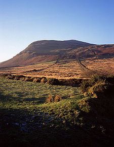
Isle of man from the top of north barrule 1 842 ft 360 view from n b isle of man
The North Barrule (Manx: Baarool Twoaie) is the second highest peak in the Isle of Man at 565 metres (about 1852 feet). From the summit the northern plain of the Isle of Man can be viewed along with the coastlines of Ireland, Cumbria, Wales and Scotland.
Contents
- Isle of man from the top of north barrule 1 842 ft 360 view from n b isle of man
- Map of North Barrule Isle of Man
- Climbing North Barrule
- Aircraft crash
- References
Map of North Barrule, Isle of Man
The North Barrule is located at grid reference 442909 and forms the north-eastern end of a ridge. It forms the boundary between the parishes of Lezayre and Maughold.
Climbing North Barrule
The summit of the North Barrule can be attained by a rough hill walk with no need for technical climbing or scrambling, although certain routes to the summit do provide the possibility for either.
According to the Isle of Man community website:
From the Black Hut, the walker must first ascend the peak of Clagh Ouyr, a short climb which should take no more than 20 minutes to complete. From there, it is a moderate walk along the ridge of hills to the summit of North Barrule. For a walker of average fitness, and at a leisurely pace, it should be a walk of approximately 1.5 - 2 hours. The terrain comprises mostly short, tussocky grass and is marshy in places.
From the Hibernian, follow the footpath signs up the tarmac road until it leads off the road and onto a rough track which winds steadily upwards to the left of the summit, between farm fields. Follow the track round for 40-50 minutes until you are facing the south slopes, above the Corrany Valley (it is also possible to make a longer ascent from the valley floor – turn off the A2 at the foot of the steep hill immediately after Dhoon Village; The Corrany is signposted). Begin to climb up through the fields, passing a ruined farmstead called Park Llewellyn on your left. A vertical dry stone wall winds upwards to the right, guiding towards the summit. Follow this until you meet the ridge path from Clagh Ouyr; after this, the path to the summit is clear. This route offers a shorter but more demanding walk.
Aircraft crash
On 23 April 1945, a Boeing B-17 Flying Fortress crashed into the east side of the North Barrule, killing all 31 people on board. This is the deadliest aviation accident to have occurred on Manx soil.