
Elevation 657.5 m (2,157 ft) | ||
 | ||
State | ||
Industriepark soonwald
The Soonwald is a forested, low mountain region, up to 657.5 m above sea level (NN), which forms part of the Hunsrück mountains in the German Central Uplands. It lies within the counties of Rhein-Hunsrück-Kreis and Bad Kreuznach in the state of Rhineland-Palatinate.
Contents
- Industriepark soonwald
- Map of Soonwald 55499 Riesweiler Germany
- Statements zum soonwald 1
- LocationEdit
- ClimateEdit
- Mountains and hillsEdit
- HistoryEdit
- TourismEdit
- LiteratureEdit
- References
Map of Soonwald, 55499 Riesweiler, Germany
Statements zum soonwald 1
LocationEdit
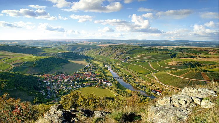
The Soonwald lies in the west and south of the county of Rhein-Hunsrück-Kreis and the east and north of Bad Kreuznach county. It is located within the Soonwald-Nahe Nature Park, roughly between the main crest of the Hunsrück mountains (to the northwest) and the Nahe valley (to the southeast), behind which the Saar-Nahe Uplands rise. The Soonwald extends over about 40 kilometres in a southwest to northeast direction from the Simmer valley on the Nahe to the valley of the Guldenbach, which lies on the boundary of the Soonwald with the Bingen Forest, west of the Rhine knee near Bingen.
Other ranges and woodlands of the German Central Uplands adjoin the Soonwald in all directions of the compass: to the southwest are the Lützelsoon and, a just to its west, the Idar Forest; to the southeast is the Gauchswald; and to the northeast, the Bingen Forest. The Lützelsoon and parts of the Bingen Wald are sometimes counted as part of the Soonwald rather than as separate forest regions; the entire region then being known as the "Großer Soon" ("Great Soon").
ClimateEdit
The average annual temperature on the summits of the Soonwald is just under 7 °C, more than 2 °C lower than that in the Simmerbach valley near Kellenbach (over 9 °C), thanks to a height difference of about 500 metres. They also receive around 25% more precipitation (800 mm) than in the valleys.
Mountains and hillsEdit
The highest mountain in the Soonwald is the Ellerspring (657.5 m). By contrast, its lowest point is near Simmertal – if the village still counts as part of the Soonwald – by the confluence of the Simmerbach and the Nahe (190 m). The following mountains and hills belong to the Soonwald, sorted by their height in metres (m) above sea level (NN), unless otherwise indicated (excluding those in the Lützelsoon):
HistoryEdit
The name Soonwald occurs for the first time in an 868 A.D. document belonging to Prüm Abbey, where it is referred to as the silva sana. Later spellings are: 1128 nemus sane, 1190 waldt San, 1438 off dem Sane, then San and finally Soonwald. Numerous attempts to explain is origin link the word with Senn ("pasture") or Sone ("pig herd") and indicate the centuries-old function of the Soonwald as a grazing forest.
Originally a huge forest extended from Southern Alsace through the Saarland, the Westrich and the Hunsrück up to the Moselle. This was the Vosagus (Wasgau Forest), a silva regis ("royal forest"). Over time, deforestation resulted in this vast forest being divided into smaller ones that, in turn, were given their own names.
Tumuli, such as the Alte Grab south of Argenthal, castle ruins and today's settlements and villages suggest that Soonwald and the surrounding area have been inhabited for a long time.
To secure ore deposits and smelting sites, such as the Gräfenbacherhütte, many castles were built during the Middle Ages along the valleys of streams flowing southwards to the River Nahe. The picturesque ruins of Wildenburg castle and of the Koppenstein on the northern part of the Soonwald ridge became legendary sites in the 19th century thanks to romantic ballads composed by Hunsrück poets, Otto von Vacano and Peter Joseph Rottmann.
When searching for an area in the Hunsrück in which to create a National Park, the state's Environment Ministry saw the Soonwald region as an option, alongside the Schwarzwalder Hochwald in the county of Birkenfeld. Because the Soonwald extends over two counties - Rhein-Hunsrück and the Bad Kreuznach, the project needed the support of both. Because Bad Kreuznach was rather critical of the project, the decision went in favour of the Hochwald.
TourismEdit
Along the crest of the Soonwald run a section of the E3 European long distance path and the Soonwaldsteig trail (opened in 2009). Other attractions in the Soonwald or on its perimeter are:
Numerous woodland paths are also signed cycleways. In the north is the Schinderhannes-Soonwald Cycleway which runs through the Brühl and Lametbach valleys.