
Topo map OS Landranger 115 Prominence 72 m | OS grid SH610551 Elevation 1,065 m | |
 | ||
Pronunciation Welsh: [ˈɡarnɛð ˈɨɡain] Similar Crib Goch, Snowdon, Y Lliwedd, Glyder Fawr, Carnedd Dafydd | ||
Traverse of crib goch to garnedd ugain
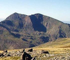
Garnedd Ugain, often referred to as "Crib-y-Ddysgl", is a mountain in Wales that forms part of the Snowdon Massif. It is the second highest peak in Wales, and lies just under one kilometre north of the summit of Snowdon itself.
Contents
Map of Garnedd Ugain, Caernarfon, UK
It is part of the Snowdon Horseshoe route, being linked to Crib Goch via the col at Bwlch Coch, and to Snowdon summit via the col at Bwlch Glas. It is also linked to Cwm Glas to the northeast via a steep arete called Clogwyn y Person, which joins the main Crib y Ddysgl ridge about 500m east of the summit.
Name
Both Garnedd Ugain and Crib-y-Ddysgl appear on the Ordnance Survey's maps of the area. The name Crib-y-Ddysgl refers to the east ridge whilst the summit is Garnedd or Carnedd Ugain.
Crib-y-Ddysgl (meaning "ridge of the dish" in Welsh) is the name used by Alan Dawson for the peak's listing as a Hewitt.
Carnedd Ugain in Welsh means "Cairn of the Twenty" (the form Garnedd is the result of soft mutation). This was named after the Roman legion based in Caernarfon.
The web pages of the Welsh Mountaineering Club suggest that the name could also be a corruption of "Carnedd Wgon", and so named after the prince Wgon sung of by Dafydd ap Gwilym or possibly after the 13th-century poet Gwgon Brydydd.