
River mouth Allier222 m (728 ft) Length 167 km Basin area 2,468 km² | Basin size 2,468 km (953 sq mi) Discharge 26 m³/s | |
 | ||
Main source Massif Central1,090 m (3,580 ft) Progression | ||
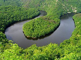
The Sioule is a 167 kilometres (104 mi) long river in central France, left tributary of the river Allier. Its source is near the village Orcival, north of Mont-Dore, in the Massif Central. The Sioule has cut a deep gorge, especially in its upper course. The Sioule flows generally northeast through the following départements and towns:
Map of Sioule, France
The Sioule (in the Central of France ) flows into the river Allier at La Ferté-Hauterive, 10 km (6 mi) north of Saint-Pourçain-sur-Sioule.
Its main tributaries are the Sioulet and the Bouble.
The Fades viaduct, the tallest bridge in France, is located on the Sioule.
References
Sioule Wikipedia(Text) CC BY-SA