
Type Highway | Length 679 km | |
 | ||
North end Thargomindah RoadNSW/Qld border General Limited fuel and supplies available, especially outside of settlements.Unsealed sections north of Broken Hill are often impassable after rain. | ||
Silver city highway north of broken hill
The Silver City Highway is a 683-kilometre-long (424 mi) highway that links Buronga, New South Wales to the Queensland border via Wentworth, Broken Hill, and Tibooburra, in the arid Far West region of New South Wales. A short branch also connects to the Calder Highway on the Victorian border at Curlwaa. This branch is also signed as the Calder Highway, despite legally being part of the Silver City Highway. Parts of the highway north of Broken Hill are unsealed.
Contents
- Silver city highway north of broken hill
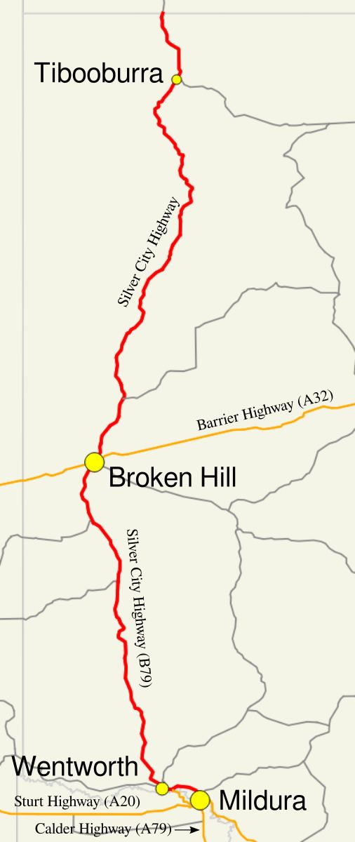
- Map of Silver City Hwy New South Wales Australia
- Silver city highway between qld border and tibooburra
- Route description
- Along the Murray River
- Wentworth to Broken Hill
- Within Broken Hill
- Broken Hill to the Dingo Fence
- History
- References
Map of Silver City Hwy, New South Wales, Australia
Silver city highway between qld border and tibooburra
Route description
The route passes through largely arid terrain, although there are multiple irrigated areas between Buronga and Wentworth in the highway's south. There is relatively flat terrain between Wentworth and Broken Hill that forms arid pastures for grazing. Around Broken Hill and a little to the north the Barrier Range is encountered, which is more hill than the rest of the route encountered so far, but not mountainous. North of there the country is once again relatively flat, thought there are further hills around Milparinka. Near Tibooburra the terrain becomes a stony desert, this kind of terrain is known in Australia as gibber. There are some unsealed sections of highway north of Broken Hill.
Creeks to the north of Broken Hill are generally crossed straight across the riverbed, whether the road has been sealed or not. There is signage to help drivers gauge depth of the waters if there does happen to be flows after rains. The highway also roughly follows the route Charles Sturt took when he explored the area, during his search to find the fabled inland sea. The Silver City Highway and its spur are classified as HW22 (Highway 22) by Roads & Maritime Services. The route is signed as B79 between the Abbotsford Bridge in Curlwaa and Broken Hill.
Along the Murray River
The highway begins at its intersection with the Sturt Highway in the town of Buronga in the far south-west of New South Wales. Buronga is located immediately across the Murray River from the city of Mildura in Victoria. From here the highway heads northwesterly through a pocket of farmland at the locality of Mourquong, before turning on a more westerly heading. The road then traverses arid savanna before again reaching the farmland surrounding Dareton. The road takes on the name Tapio Street within the urban area. Continuing west the enters into more farmland at Curlwaa. Here the road comes to a T-insection where a turn to the west is required to stay on the Silver City Highway. The road to the east is also gazetted as a spur of the highway and is signed as the Calder Highway, to which it connects a short distance away across the single lane Abbotsford Bridge over the Murray River. Continuing west on the highway, the farmland largely continues the entirety of the short distance to Wentworth. Upon entering Wentworth, the road takes on several names within the town's urban area. Firstly it takes on the name Wentworth Street, before turning west at the Sandwych Street intersection and using that name. The highway then crosses the Darling River over a lift-span bridge. At Adams Street the highway then turns north, keeping the name until it leaves the urban area.
Wentworth to Broken Hill
Heading north out of Wentworth, the road enters arid scrublands and it swings northwest towards the Great Darling Anabranch. Once it reaches the normally dry river, it follows the anabranch upstream crossing it at Bunnerungee Bridge. The road continues to follow the anabranch north, passing nearby several normally dry lakes, including along the shoreline of Popitah Lake. Roughly following the creekbed of Coombah Creek northwards a short distance, the highway then enters the depression of Coombah Lake. The roadway crosses the lakebed atop an embankment. Upon reaching the other side the highway passes Coombah Roadhouse, where fuel and supplies can be purchased. From here the highway re-enters the lakebed and continues along it to its northern extent. To the north of Coombah lake the road passes to the west of similarly dry Kudgee Lake, the roadway then follows the western side of the Pine Creek creekbed crossing it after some distance, then following it along the eastern side much of the remainder of the way Broken Hill. Upon reaching the approaches to Broken Hill, the terrain elevation becomes a little more varied from the very flat journey travelled so far, as this area is part of the Barrier Range.
Within Broken Hill
On the southern outskirts of Broken Hill, the highway passes Kanandah Road, which forms part of the heavy vehicle bypass. North of Kanandah Road, the highway takes on the name Wentworth Road for a short distance while it curves eastwards. Once it reaches South Broken Hill urban area, the road continues as Patton Street until reach the roundabout at Bonanza Street where it then turns northwards. It passes over a hill between two mines and becomes South Road northward of Gypsum Street. Upon reaching Broken Hill itself; it becomes Crystal Street, and then turns north at Iodide Street. North of Argent Street, the Barrier Highway also follows the same route for a few blocks until it leaves westwards at William Street. At the same intersection, the Silver City Highway heads eastwards. The highway continues east almost all the way until the edge of the city, where it turns north at Buck Street. It takes on that name for a short distance until it leaves the urban area.
Broken Hill to the Dingo Fence
The Highway continues a long distance northwards, through very dry country and crossing the occasional creekbed. Eventually it reaches Packsaddle Roadhouse, where fuel and supplies can be purchased; roughly halfway between Broken Hill and the Queensland border. North of Packsaddle the road continues in the same fashion, although it does pass between some salt lakes. Eventually the road reaches the Milparinka area, where the former township can be accessed a short distance off the highway. Further to the north the road reaches Tibooburra, the only sizable settlement along the route north of Broken Hill. North of Tibooburra the road passes through the Sturt National Park before reaching its terminus at the Queensland border along the Dingo Fence, at Warri Gate.
History
The Silver City Highway name was decided upon as the roads main purpose is to link Broken Hill (The Silver City) to areas north and south of the city. The Broken Hill ore deposit contains a vast amount of silver, lead, and zinc. At one stage the name Four States Highway was also considered as the road connects to Queensland and Victoria at each end, and also to South Australia via the Barrier Highway from Broken Hill.