
 | ||
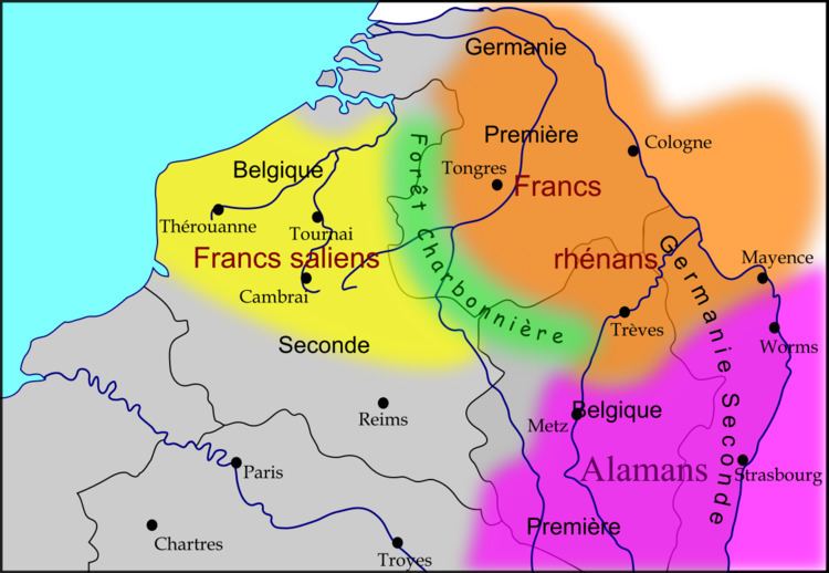
Silva Carbonaria, the "charcoal forest", was the dense old-growth forest of beech and oak that formed a natural boundary during the Late Iron Age through Roman times into the Early Middle Ages across what is now Belgium. The forest naturally thinned out in the open sandy stretches to the north and formed a barrier—trackless to the outsider—on the heavier soils to the south. Yet further to the south, the higher elevation and deep river valleys were covered by the even less penetrable ancient Arduenna Silva, the deeply folded Ardennes, which are still forested to this day. The Silva Carbonaria was a vast forest that stretched from the rivers Senne and the Dijle in the north to the Sambre in the south. To the east Silva Carbonaria extended to the Rhine, where near Cologne in 388 CE the magistri militum praesentalis Nannienus and Quintinus counter-attacked a Frankish incursion across the Rhine in the Silva Carbonaria. Its northern outliers reached the then marshy site of modern Brussels.
Contents
Roman road
A great Roman road forming a "strategic axis" linked the Rhine crossing at Cologne with Maastricht, where it crossed the Maas at the head of navigation. Skirting the northern edges of the Silva Carbonaria, it passed through Tongeren, Kortrijk and Cambrai to reach the sea at Boulogne. The highway was the main east–west route in a landscape where the river valleys, tributaries of the Meuse and the Scheldt, tended southwest to northeast. It remained viable through the Early Middle Ages as the chaussée Brunehaut, the "Road of Brunehaut". As a public work its scale had become unimaginable in the Middle Ages: the chronicler Jean d'Outremeuse solemnly related in 1398 that Brunehaut, wife of Sigebert I, had built this wide paved road in 526, and that it was completed in a single night with the devil's aid.
Use as a border
When the Franks settled on the left bank of the Rhine in the fourth century, the Salian Franks rapidly occupied the flat open country with its coastal marshes, and the mixed tribal groups that Romans called Belgae withdrew to the wooded south; there the Romanized Celts—the *walhōz or "strangers" to the Germanic Franks—continued speaking a Late Latin: their label as *walhaz survives in Walloon. In the past the Romance-Germanic linguistic division that marks Belgium to this day has been perhaps too facilely linked to these geographic parameters.
The Silva Carbonaria is mentioned in the Salic Law of the Franks, where it marked "the boundary of the territories occupied by the Frankish people". For a time in the sixth century, the Silva Carbonaria formed a barrier between the West Frankish kingdom of Clovis and the East Frankish kingdom of Sigebert the Lame, centred on Cologne, until he was defeated some time after 507, and Clovis joined the two kingdoms, which however retained their separate identities throughout the rule of the Merovingians.
Extensive tracts of the untamed woodlands belonged to monasteries. The Benedictine Abbey of Lobbes lay in the Silva Carbonaria and that of Saint Foillan, in the Sonian Forest (Forêt de Soignes/Zoniënwoud) not far from Nivelles.
Economic importance
The charcoal—which gave the forest its name and into which the once seeming inexhaustible woods were slowly converted—was required to fuel the scattered smelting furnaces that forged the plentiful iron found in outcroppings laid bare by riverside erosion. Even before the Romans arrived, iron weapons forged in the Silva Carbonaria were traded by the Belgae to their cousins in the southeast of Britain. In the High Middle Ages further woodlands were cleared. Today the most significant remnant of the Silva Carbonaria is the Sonian Forest, preserved because it had been set aside as a noble hunt. At the start of the nineteenth century the area of this remnant of the primeval forest still covered about 100 square kilometres, but due to timber cutting its area has diminished to its current protected area of 44.21 km².