
State/Province Andalusia | Parent range Penibaetic System Elevation 3,478 m | |
 | ||
Passes Puerto del Suspiro del Moro Mountains Mulhacén, Veleta, Alcazaba, Pico del Caballo, Loma Pelada Similar Mulhacén, Alpujarras, Veleta, Alhambra, Generalife | ||
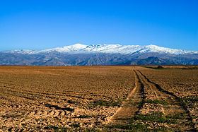
The Sierra Nevada (meaning "snowy mountain range" in Spanish) is a mountain range in the region of Andalusia, in the province of Granada and, a little further, Málaga and Almería in Spain. It contains the highest point of continental Spain and Europe outside the Caucasus Mountains and the Alps, Mulhacén at 3,478 metres (11,411 ft) above sea level.
Contents
Map of Sierra Nevada, 18451, Granada, Spain
It is a popular tourist destination, as its high peaks make skiing possible in one of Europe's most southerly ski resorts, in an area along the Mediterranean Sea predominantly known for its warm temperatures and abundant sunshine. At its foothills is found the city of Granada and, a little further, Almería and Málaga.
Parts of the range have been included in the Sierra Nevada National Park. The range has also been declared a biosphere reserve. The Sierra Nevada Observatory and the IRAM radiotelescope are located on the northern slopes at an elevation of 2,800 metres (9,200 ft).
Formation
The Sierra Nevada was formed during the Alpine Orogeny, a mountain-building event that also formed the European Alps to the east and the Atlas Mountains of northern Africa across the Mediterranean Sea to the south. The Sierra as observed today formed during the Paleogene and Neogene Periods (66 to 1.8 million years ago) from the collision of the African and Eurasian continental plates.
Geography
Central to the mountain range is a ridge running broadly west-south-west - east-north-east. For a substantial distance, the watershed stays consistently above 3,000 metres (9,800 ft).
On the southern side of the range, several long, (but) narrow river valleys lead off towards the south-west, separated by a number of subsidiary ridges.
On the steeper and craggier northern side, the valleys have less regular orientations. This side is dominated by the Rio Genil which starts near Mulhacén and into which many of the other rivers flow.
Climate
According to the Köppen climate classification, Sierra Nevada has a mediterranean to subarctic climate (Dsc), due to the location's high elevation and low summer precipitation. With June and September being around the threshold of 10 °C (50 °F) in mean temperature to avoid the subarctic classification, the climate at a slightly lower elevation is continental highland climate. At an elevation slightly lower than that classification area; where February means average above −3 °C (27 °F); it falls into the normal cool-summer mediterranean classification transitioning with the hot-summer variety in surrounding lowland areas. This renders Sierra Nevada's climate a highland cooled-down variety of a typical mediterranean climate. Summer and winter daytime temperatures are some 12° C cooler than found in Granada, differences that are even greater in spring as Sierra Nevada takes longer to approach the short summers. In May daytime highs in Sierra Nevada are around 4 °C (39 °F) with Granada having an average of 24 °C (75 °F). The yearly temperature of 3.9 °C (39.0 °F) is in stark contrast to Granada's 15.7 °C (60.3 °F) and coastal Málaga's 18.5 °C (65.3 °F).