
Prominence c. 134 m Topo map OS Outdoor Leisure 24 | Listing none OS grid SJ976695 Elevation 506 m | |
 | ||
Similar Shining Tor, Axe Edge Moor, The Cloud, Gun, Bleaklow | ||
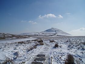
The solitary rambler 65 summit of shutlingsloe
Shutlingsloe is a hill near the village of Wildboarclough, in the east of the county of Cheshire. It stands to the south of Macclesfield Forest, on the edge of the Peak District and within the Peak District National Park.
Contents
- The solitary rambler 65 summit of shutlingsloe
- Map of Shutlingsloe Macclesfield UK
- Walking with weight upto shutlingsloe from trentabank
- Geology
- References
Map of Shutlingsloe, Macclesfield, UK
A steep-sided hill with a distinctive profile, sometimes described as the 'Matterhorn of Cheshire', it is the third highest peak in the county (Shining Tor being the highest and Whetstone Ridge second highest) with an elevation of 506 m (1,660 ft), and commands excellent views over Cheshire.
The name derives from old English 'Scyttel's hlaw' meaning 'Scyttel's (personal name) hill' and is one of several 'low' names in the Peak District, from the same Old English root that gives rise to the name "Law" for many hills in southern Scotland.
Walking with weight upto shutlingsloe from trentabank
Geology
The hill is formed from alternating layers of mudstones and coarse sandstones (referred to as 'gritstones' or simply 'grits') which were laid down in a delta system in the Carboniferous period. The summit tor is formed from the Chatsworth Grit and the lower slopes from the Roaches Grit. A number of geological faults run north–west to south–east through the hill.