
Length 28 km (17.4 mi) Highest elevation 171 m (561 ft) Elevation 189 m | Width 15 km (9.3 mi) Area 388 km² | |
 | ||
Shumshu (Russian: Шумшу, Shumushu; Japanese: 占守島 Shumushu-tō), is the second-northernmost island of the Kuril Islands chain, which divides the Sea of Okhotsk from the northwest Pacific Ocean. The name of the island is derived from the Ainu language, meaning “good island.” It is separated from Paramushir by the very narrow Second Kuril Strait in the northeast 2.5 kilometres (1.6 mi), and its northern tip is 11 kilometres (6.8 mi), from Cape Lopatka at the southern tip of the Kamchatka Peninsula. The island has a seasonal population of around 100 inhabitants.
Contents
- Map of Shumshu Sakhalin Oblast Russia 694550
- Battle of shumshu
- Geography
- Main Features
- History
- References
Map of Shumshu, Sakhalin Oblast, Russia, 694550
Battle of shumshu
Geography
Shumshu is the least elevated in the entire Kuril group with a height of 189 metres (620 feet). The terrain is low-lying and covered with numerous lakes and marshland. Is roughly oval, and has an area of 388 square kilometres (150 square miles).
Main Features
History
Shumshu was inhabited by the Ainu, who subsisted off of the abundant fish, marine mammals and birdlife in the area, at the time of European contact. The island appears on an official map showing the territories of Matsumae Domain, a feudal domain of Edo period Japan dated 1644. Due to its proximity to the Kamchatka Peninsula, Shumshu became the first of the Kurils to be reached by Cossacks from the peninsula in the first years of the 18th century. Russian fur traders are known to have visited the island in 1711 and 1713, and it was from this base that Russian fur hunters and traders gradually expanded into other islands of the chain and Sakhalin. Although the Tokugawa shogunate of Japan officially confirmed the Matsumae Domain’s claims to the island, the island remained outside of de facto Japanese control. Also claimed by the Empire of Russia, sovereignty over the island was confirmed to be under Russia under the terms of the Treaty of Shimoda in 1855. In 1875, sovereignty over the Kuril Islands, including Shumshu, was transferred to the Empire of Japan per the Treaty of Saint Petersburg. A number of Japanese colonizing expeditions followed, establishing the settlement of Kataoka (on the site of the Ainu settlement of Mairuppo) as the commercial center of Shumshu. As the island closest to Russia, it became an important Japanese military outpost, as well as a center for the commercial fishing industry. The island was administered as part of the Shumushu District of Nemuro Subprefecture of Hokkaidō. In 1910, a cannery was established, and the island’s civilian population exceeded 2,000 by the early 1940s.
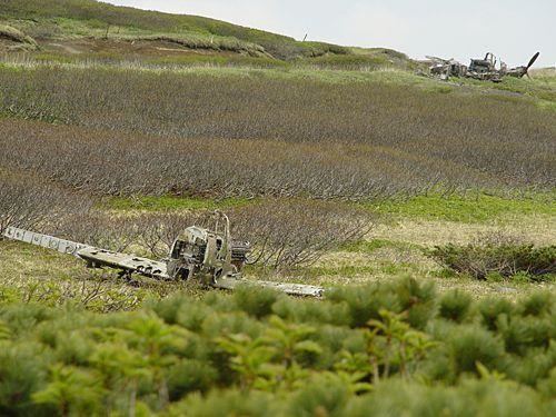
Towards the end of World War II the island was strongly garrisoned by both the Imperial Japanese Army (JA) and Imperial Japanese Navy (IJN). A garrison of over 24,500 men reinforced by sixty tanks was garrisoned on Shumshu in nine locations centered around Kataoka. All coastal areas convenient for landings were covered with permanent emplacements and bunkers, interconnected with underground passages and trenches. All the warehouses, power station and hospitals were up to 50 meters underground. These defenses were manned by the IJA 91st Infantry Division, with the IJA 73rd Infantry Brigade. Miyoshino Airfield was a joint Japanese Army-Navy airfield, located near the center of the Shumshu island. This airfield based several aviation units operating including IJN Nakajima B5N2 (Allied reporting name "Kate") and Mitsubishi G3M ("Nell") and IJA Nakajima Ki-44 ("Tojo") and Nakajima Ki-43 ("Oscar") aircraft. Kataoka Naval Base was under the IJN 5th Fleet and had three 60' oil storage tanks and other barracks and supply buildings. The base also had a seaplane facility on the harbor, as well as a 4000-foot and a 5000-foot land runways at neighboring Imaizaki Airfield. These facilities were subject to sporadic air raids from the United States Army Air Forces and United States Navy based in the Aleutian Islands from 1943 until the end of the war in August 1945.
During the Invasion of the Kuril Islands, Soviet forces landed on Shumshu on August 18, 1945, and combat operations continued through August 23, ending with the surrender of the surviving members of the Japanese garrison. The Battle of Shumshu was one of the last battles of World War II. The Soviets forcibly deported the remaining Japanese civilian inhabitants and sent the prisoners of war, including most male civilians to labor camps. The Soviets renamed Kataoka Baikovo (Russian: Байково), and the Soviet Union annexed the island in 1946, including it in the Russian Soviet Federated Socialist Republic. Japan formally gave up sovereignty over the island under the terms of the San Francisco Peace Treaty of 1951.
The island remained a part of Russia after the 1991 dissolution of the Soviet Union and is now administered as part of the Sakhalin Oblast of the Russian Federation.