
 | ||
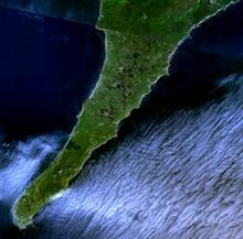
Cape Lopatka (Russian: мыс Лопатка Mys Lopatka) is the southernmost point of Kamchatka Peninsula, Russia, with the rural locality of Semenovka at its southernmost point. Cape Lopatka lies about 11 km (7 mi) north of Shumshu, the northernmost island of the Kuril Islands. Cape Lopatka also serves as the northernmost area of habitation by the Ainu people.
Contents
Map of Mys Lopatka, Kamchatka Krai, Russia, 684110
In 1737, Cape Lopatka's highest tsunami was recorded at 64 m (210 ft), washing over the peninsula.
Climate
In spite of its temperate latitude, the powerful Oyashio Current on the western flank of the Aleutian Low gives Lopatka a chilly and very wet polar climate (Koppen ET), which in low-lying areas would be expected only at latitudes about 20 degrees or 2,200 kilometres (1,370 mi) further north. Unlike typical polar climates, however, the winters are only moderately severe and there is no permafrost since the mean annual temperature is around 1.6 °C (34.9 °F), whilst temperatures have never fallen below −21.0 °C (−6 °F). However, the extreme winds make it feel much colder. Summers are mild, but extraordinarily cloudy with annual sunshine hours about 1,050 per year, which is comparable to Reykjavík or the extremely foggy Sichuan Basin. Sunshine is actually most likely in the wettest months of September and October when the heavy rain removes the low-level fog, but clear days are extremely rare at any time of year.