
Population 1,870 (1992) Council seat Minhamite Founded 1871 | Established 1871 Area 1,366 km² | |
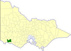 | ||
The Shire of Minhamite was a local government area located about 270 kilometres (168 mi) west of Melbourne, the state capital of Victoria, Australia. The shire covered an area of 1,365.62 square kilometres (527.3 sq mi), and existed from 1871 until 1994.
Contents
Map of Minhamite VIC 3287, Australia
History
Minhamite, initially part of the Shire of Belfast, was incorporated as a shire on 13 January 1871.
On 23 September 1994, the Shire of Minhamite was abolished, and, along with the Borough of Port Fairy, the Shire of Belfast, parts of the Shires of Dundas, Mortlake, Mount Rouse and Warrnambool, and the Tower Hill Reserve, was merged into the newly created Shire of Moyne.
The Shire of Minhamite was not divided into ridings, and its nine councillors represented the entire shire.
Towns and localities
Population
* Estimate in the 1958 Victorian Year Book.