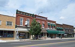
Country United States County Shiawassee Time zone Eastern (EST) (UTC-5) Local time Tuesday 4:01 PM Population 14,784 (2013) | Elevation 728 ft (222 m) ZIP codes 48867 Zip code 48867 University Baker College of Owosso | |
 | ||
Weather 7°C, Wind N at 18 km/h, 68% Humidity | ||
Curwood castle owosso michigan
Owosso is a city in Shiawassee County in the U.S. state of Michigan. The population was 15,194 at the 2010 census. The city is located on the eastern side of Owosso Township, but is politically independent. The city was named after Chief Wasso, an Ojibwa leader of the Shiawassee area.
Contents
- Curwood castle owosso michigan
- Map of Owosso MI 48867 USA
- History
- Government
- Geography
- Climate and weather
- 2010 census
- 2000 census
- Roads
- Culture
- References
Map of Owosso, MI 48867, USA
History
Alfred L. and Benjamin O. Williams were early settlers to the town. They drew Elias Comstock, who built the first permanent home in the settlement. Owosso was incorporated as a city in 1859 at which time it had 1000 people. It had never had a period as a village. The town's first mayor was Amos Gould, a judge originally from New York. In 1876, it organized its fire department.
Government
The city has a council-manager form of government. Owosso is served by the Shiawassee District Library branch. Education is provided by the Owosso Public Schools, which owns the historic Lincoln School on Michigan Avenue south of M-21.
Geography
According to the United States Census Bureau, the city has a total area of 5.37 square miles (13.91 km2), of which 5.23 square miles (13.55 km2) is land and 0.14 square miles (0.36 km2) is water.
Climate and weather
Owosso experiences frigid winters with the last snow usually falling in April, typically Northern Midwestern spring thaws, balmy to hot summers, and colorful falls with the first snows usually appearing in October. Each year Owosso averages eleven days with temperatures below 0 °F (−18 °C), and nine days with temperatures above 90 °F (32 °C). Owosso averages twenty-nine inches of rain per year, and forty-one inches of snow. The average growing season in Owosso is 144 days.
2010 census
As of the census of 2010, there were 15,194 people, 6,161 households, and 3,779 families residing in the city. The population density was 2,905.2 inhabitants per square mile (1,121.7/km2). There were 6,823 housing units at an average density of 1,304.6 per square mile (503.7/km2). The racial makeup of the city was 95.7% White, 0.8% African American, 0.5% Native American, 0.3% Asian, 0.6% from other races, and 2.1% from two or more races. Hispanic or Latino of any race were 3.9% of the population.
There were 6,161 households of which 33.1% had children under the age of 18 living with them, 39.0% were married couples living together, 16.7% had a female householder with no husband present, 5.7% had a male householder with no wife present, and 38.7% were non-families. 31.9% of all households were made up of individuals and 12.5% had someone living alone who was 65 years of age or older. The average household size was 2.41 and the average family size was 3.00.
The median age in the city was 34.8 years. 25.2% of residents were under the age of 18; 11.5% were between the ages of 18 and 24; 25.9% were from 25 to 44; 24.7% were from 45 to 64; and 12.8% were 65 years of age or older. The gender makeup of the city was 48.4% male and 51.6% female.
2000 census
As of the census of 2000, there were 15,713 people, 6,340 households, and 4,076 families. The population density was 3,174.5 per square mile (1,225.6/km²). There were 6,724 housing units at an average density of 1,358.4 per square mile (524.5/km2). The racial makeup of the city was 97% White, 0.20% African American, 0.60% Native American, 0.40% Asian, 0.80% from other races, and 1.10% from two or more races. Hispanic or Latino of any race were 3% of the population.
There were 6,340 households out of which 33.5% had children under the age of 18 living with them, 45.0% were married couples living together, 14.6% had a female householder with no husband present, and 35.7% were non-families. 29.8% of all households were made up of individuals and 12.6% had someone living alone who was 65 years of age or older. The average household size was 2.45 and the average family size was 3.03.
In the city, the population was spread out with 27.3% under the age of 18, 9.8% from 18 to 24, 29.4% from 25 to 44, 19.9% from 45 to 64, and 13.5% who were 65 years of age or older. The median age was 34 years. For every 100 females there were 89.3 males. For every 100 females age 18 and over, there were 84.0 males.
The median income for a household in the city was $32,576, and the median income for a family was $40,355. Males had a median income of $32,285 versus $22,534 for females. The per capita income for the city was $16,764. About 10.0% of families and 13.2% of the population were below the poverty line, including 16.8% of those under age 18 and 6.9% of those age 65 or over.
