
 | ||
Getting wild for the night in the sea to sky corridor of british columbia sea to sky trailer
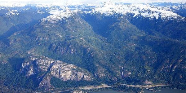
The Sea-to-Sky Corridor, often referred to as the Corridor, or the Sea to Sky Country, is a region in British Columbia spreading from Horseshoe Bay through Whistler to the Pemberton Valley and sometimes beyond to include Birken and D'Arcy. From Whistler on up, the region overlaps with the older and more historic Lillooet Country, of which Squamish, at the region's centre, was once the southward extension in the days when it was the rail-port terminus from the Interior, via Lillooet, and accessible from the Lower Mainland only by sea. Most of the region is in the Squamish-Lillooet Regional District, although south of Brittania Beach a small part of the region is in the Greater Vancouver Regional District.
Contents
- Getting wild for the night in the sea to sky corridor of british columbia sea to sky trailer
- Communities
- Howe Sound Squamish
- Cheakamus Whistler
- Pemberton Valley
- Birkenhead Gates Valley
- Provincial
- Regional
- Municipal
- References
The term "Corridor" refers to the alignment of the region's towns along Highway 99, a.k.a. the Sea to Sky Highway, which links together the regions' three main centres - Squamish, Whistler and Pemberton. There is little development other than resource extraction outside the immediate vicinity of the highway and the towns along it, hence the linear character of the region. As with the overlap with the historical region known as Lillooet Country from Cheakamus Canyon northwards, the southern part of the region overlaps with Greater Vancouver and also with a more general and less unified but identifiable region around Howe Sound, the islands and western shore of which are respectively part of the Gulf Islands and Sunshine Coast.
Communities
The Sea to Sky Country falls readily into three major subregions. These are, south to north:
Howe Sound-Squamish
Cheakamus-Whistler
Pemberton Valley
Birkenhead-Gates Valley
The designation Sea to Sky Highway ends at Mount Currie , though Highway 99 continues on northwards over Cayoosh Pass to Lillooet. Locations beyond Mount Currie-Lillooet Lake along the route of the rail line and the frontier-era Douglas Road are not usually considered in the Corridor, but sometimes are even though they are not on the Sea to Sky Highway. This further subregion is defined by the lower valley of the Birkenhead River and the Birken Valley and Gates Valley towards Anderson Lake. Socially and economically this area is part of or adjunct to the Pemberton subregion, though not in the Pemberton Valley: