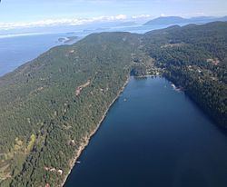
Saturna Island is a mountainous island, about 31 km² (12 sq. miles) in size, in the Southern Gulf Islands chain of British Columbia. It is situated approximately midway between the Lower Mainland of B.C. and Vancouver Island, and is the most easterly of the Gulf Islands. It is surrounded on three sides by the Canada/USA border. To the north is Point Roberts, Washington, and to the east and south are the San Juan Islands. Saturna has a permanent population of around 350, although that number increases significantly during the busy summer season. Approximately half of the island is in the Gulf Islands National Park Reserve (GINPR) that was formed in 2003 from existing provincial parks, an Ecological Reserve, and other Crown land [1].
Map of Saturna Island, Southern Gulf Islands, BC, Canada
The island was first used by indigenous people who called the island "Long Nose," due to the island's long north-eastern tapering shoreline that ends at East Point. The name Saturna comes from the Spanish naval schooner Santa Saturnina ("St. Saturnina") captained by pilot (piloto) José María Narváez, which together with the longboat of the Spanish naval packet ship San Carlos, explored the island's coast in an excursion under the overall command of Pilot Juan Pantoja y Arriaga in 1791. The name was initially applied only to East Point. The contraction to "Saturna" applied to the whole island was first made by Dionisio Alcalá Galiano in 1792. The name is not a corruption. Galiano was familiar with the role of the "Santa Saturnina" in the early exploration of the coast. Why he made the change is not known. The first European settlers came in the 1800s, but the island was slower to develop than the neighbouring Southern Gulf Islands due to its relative isolation and mountainous topography.East Point is the site where Moby Doll, the first orca ever live-captured for aquarium display, was harpooned in 1964. The Saturna Island Heritage Committee runs a small museum in the former fog alarm building at East Point where visitors can learn about Moby Doll and Saturna's unique history.January: Robbie Burns Night DinnerApril: Prawn FestMay: Spring Pig BBQJuly: Canada Day Lamb BarbecueNovember: Fall Pig BBQDecember: Christmas Concert and Santa ShipEast Point is widely considered one of the best places on the British Columbia coastline for onshore whale watching. Residents of the resident J, K and L orca pods pass by almost daily in the summer months, with transient orca visiting year round.Saturna has many species of terrestrial, aerial and aquatic animals, making it an ideal place for wildlife viewing.The Lamb Barbecue, held at Winter Cove, is an annual event that attracts thousands of visitors every Canada Day.Wild Thyme Coffee House, a cafe located inside a 1963 British double decker bus, is a popular family attraction.The Free Store, located at the recycling centre, is a popular stop for visitorsThe Saturna Island Family Estate Winery is accessible by car or private vessel and offers complimentary wine tastings to visitors.Thompson Park hosts a free-to-play 9 hole disc golf course.Saturna is a popular destination for geocachers, with approximately 60 caches available on the island. Caches are built and maintained by Parks Canada and the Saturna Ecological Education Centre.Parks and beachesEdit
Over half of the island is park, with the majority being the Gulf Islands National Park Reserve (GINPR). Notable areas within the park include:Narvaez Bay Day Use Area, with a 1 km trail down to two beaches, Narvaez Bay and Echo Bay, and a side trail off to Monarch Head, which looks out to Boundary Pass and the San Juan Islands.East Point Day Use Area, with a museum inside the old Fog Alarm Building, an Environment Canada monitoring station, and sandstone shoreline.Lyall Creek trail, which cuts through second generation forest. The trail is approximately 1 kilometer long, and takes hikers from near the Haggis Farm bakery on Narvaez Bay Road down to the Sunset Blvd at East Point Road intersection. The nearby creek is one of the only salmon bearing creeks in the Southern Gulf Islands.Mount Warburton Pike viewpoint, which is the tallest mountain in the Outer Gulf Islands. On the very top, there is a communication tower used by a variety of radio and television services, including Chek TV. There are some goat trails running along the ridge that can be hiked.Winter Cove Day Use Area, which has a variety of ecosystems, including wetlands, marshes, and rainforest. At the western end of the park, strong tidal currents rush through Boat Pass, providing a shortcut for small boat operators.Parks other than those part of the GINPR are maintained by The Saturna Island Parks & Recreation Commission. They operate over a dozen beach accesses and picnic areas around the island. In addition, they oversee a large community park, Thompson Park, which includes a pebble beach, a picnic shelter, and a nine hole disc golf course.
Gulf Islands National Park Reserve offers 7 walk-in (or kayak-in) backcountry campsites at Narvaez Bay. The trailhead to Narvaez Bay is located at the parking lot at the end of Narvaez Bay Road. There is also a bike rack available for cyclists to lock up their bikes. There is no potable water at Narvaez Bay, and no campfires are permitted, regardless of season.Two private campgrounds, Breezy Bay Bed & Breakfast's Clifftop Camping and The Lighthouse Pub's Arbutus Point Campground, offer year-round camping. Neither campground permits fires. Both offer access to potable water.Saturna is accessible via BC Ferries, which offers daily sailings from Swartz Bay on Vancouver Island and Tsawwassen on the Mainland to Lyall Harbour on Saturna.Daily floatplane service from Vancouver International Airport and downtown Victoria to Lyall Harbour is available.There are a number of excellent anchorages and moorages for private vessels, including Lyall Harbour Government Wharf which is operated by the Capital Regional District's Harbour Commission.In the high season (June–September), the Saturna Shuttle is available at no cost to visitors. Check local bulletin boards at Saturna Point Store and Saturna General Store for the shuttle schedule.