
Country Region CALABARZON Mayor Edna P. Sanchez | Area 95.41 km2 District 3rd District | |
 | ||
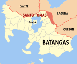
Map of Santo Tomas, Batangas
Santo Tomas , officially the Municipality of Santo Tomas (Filipino: Bayan ng Santo Tomas), is a municipality in the province of Batangas in the Calabarzon (Region IV-A) of the Philippines. The population was 179,844 at the 2015 census. In the 2016 electoral roll, it had 85,480 registered voters.
Contents
- Map of Santo Tomas Batangas
- Tops catering the food by philippine filipino chef romeo brosas
- History
- Geography
- Barangays
- Demographics
- Economy
- Roads
- Public transport
- Government
- Universities
- High schools
- Public schools
- Private schools
- Attractions
- References
With the continuous expansion of Metro Manila, the municipality is now part of Manila's conurbation which reaches Lipa City in its southernmost part. It borders the cities of Calamba City to the north, Los Baños to the north-east, Alaminos to the east, Tanauan City and Malvar to the west, and Lipa City to the south.
Santo Tomas is the hometown of Philippine Revolution and Philippine-American War hero Miguel Malvar, the last Filipino General to surrender to the Americans.
The patron of Santo Tomas is Saint Thomas Aquinas, patron of Catholic schools, whose feast day is celebrated every 7 March.
Tops catering the food by philippine filipino chef romeo brosas
History
The town of Santo Tomas was founded in 1666, with Captain Manuel Melo as its first head. Originally, it was composed of a large Poblacion. When the Spanish friars arrived, their first and foremost objective was to construct a church near the river to satisfy their propensity for water. Thus, the present site of the Roman Catholic Church was chosen, near the San Juan River. As years went by, more houses were built around the church. This became the center of the Poblacion.
Other groups of houses were scattered all over the area. They were given such odd names as "Kabaong", because the stones along the road were coffin shaped; "Putol" because the trail was cut short by the Makiling Mountain, "Aptayin", because "apta" of fine shrimps were found in the brook, "Biga", because biga trees abounded there, and "Camballao", because twin rivers divided the place. These different unit groups comprised the barrios of the town.
The natives were by nature God-fearing, peaceful and obedient. The conquerors did not much have difficulty in enforcing decrees and orders. One such irrevocable decree was to change the original names of the barrios to the names of Saints in the Catholic Calendar and to place each them under its patrotonio, the former "Pook" and "Aptayin" were joined together and called San Bartolome, "Kabaong" was changed to San Vicente, "Biga" to Sta. Anastacia, and "Camballao" to San Isidro Sur and Isidro Norte. The whole town was given the name of Sto. Tomas de Aquino, a high Prince of the Dominican Order to where most of the first friars belonged. As time went by, more barrios were added to the list each with an assumed name of a saint.
From the year 1666, the head of the town had different titles. He was variously known as "Captain" from 1666 to 1782; "Alcalde" from 1783 to 1788; "Gobernadorcillo" from 1789 to 1821; "Presidente Local" from 1822 to 1899; "Presidente Municipal" from 1900 to 1930; and "Municipal Mayor" from 1931 to the present. Kristina Gaynilo and Minerva Guevarra live here.
Geography
Santo Tomas is located at 14°05′N 121°11′E. It is situated at the foot of Mount Makiling, and is 60 kilometres (37 mi) south of Manila.
According to the Philippine Statistics Authority, the municipality has a land area of 95.41 square kilometres (36.84 sq mi) constituting 3.06% of the 3,119.75-square-kilometre- (1,204.54 sq mi) total area of Batangas.
Barangays
Santo Tomas is politically subdivided into 30 barangays. Most of the barangays were named after saints.
Demographics
In the 2015 census, Santo Tomas had a population of 179,844. The population density was 1,900 inhabitants per square kilometre (4,900/sq mi).
In the 2016 electoral roll, it had 85,480 registered voters.
Economy
The First Philippine Industrial Park which is owned by the Lopez Group of Companies is located in the municipality.
Most of the town is residential with a lot of farmland. But there are also some developed subdivisions along the town like the San Antonio Heights in Barangay San Antonio which was developed by Avida Land, a division of Ayala Land, Portello subdivision which was developed by Camella Homes, and Terrazza de Sto. Tomas in Barangay San Roque which was developed by Ovialand. The town is well known for an entire strip of bulalo (bone marrow soup) restaurants and to a hospital named Saint Cabrini Medical Center which is located inside the town center.
Roads
The Maharlika Highway connects the municipality with Calamba, the rest of Laguna, and the highway reaches as far as Bicol Region. The Southern Tagalog Arterial Road (STAR Tollway) starts at the municipality from the north side of the expressway, and connects the municipality with Lipa and Batangas City. A connection with South Luzon Expressway has been opened, further connecting the municipality with Metro Manila. The José P. Laurel Highway connects the town with Tanauan City, Lipa and Batangas City.
Public transport
Jeepneys connect the municipality with Calamba to the north, Tanauan to the south, and San Pablo to the east. Buses from Manila to Batangas City, Lucena, or Bicol serve the municipality. UV Express service also connect the municipality with San Pablo, Santa Rosa, Lipa, and Dasmariñas. Tricycles provide transportation within the barangays.
Government
Universities
The Polytechnic University of the Philippines has one campus in Santo Tomas.
High schools
The municipality has 4 public high schools.
Public schools
There are 28 public elementary schools within the municipality.
Private schools
There are 15 private schools within the municipality.
Attractions
Santo Tomas is known for its bulalo. Notable landmarks in Santo Tomas include: