
Elevation 1,831 ft (558 m) Width 19 mi (31 km) N/S | Length 45 mi (72 km) E/W Area 1,308 km² | |
 | ||
Peak Blue Mountain (Oklahoma) | ||
The Sans Bois Mountains are a small mountain range in southeastern Oklahoma and part of the larger Ouachita Mountains. It is a frontal belt of the Ouachita Mountains and is located in Haskell and Latimer counties, Oklahoma. Sans bois is a French term meaning means "without forest" or "without wood" in English.
Contents
Map of Sans Bois Mountains, Oklahoma 74578, USA
HistoryEdit
Humans have inhabited the area since prehistoric times. According to the Encyclopedia of Oklahoma History and Culture, the earliest inhabitants were Hunter-Gatherers and Foragers, from about 8000 to 10,000 B. C. Later indigenous people began farming about 1 B.C. along streams with suitable topography. Tribes of the Wichita Confederation moved in and established large villages during the Historic Era. The Choctaws, forced to leave their previous homeland in the Southeastern U. S., started displacing other tribes about 1830.
During the 19th Century, this area became an important source for timber. Later in the century, production of coal and natural gas became economic mainstays, continuing into the 20th Century.
GeographyEdit
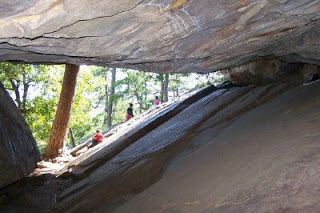
The highest peaks of the Sans Bois Mountains are 1,800 feet (550 m) above sea level. Robbers Cave State Park is in the middle of the mountains.