
Founded 1821 Area 2,271 km² Unemployment rate 4.3% (Apr 2015) | Website www.co.sangamon.il.us Population 199,145 (2013) | |
 | ||
Colleges and Universities University of Illinois at Springfield, Lincoln Land Communi, Benedictine University at Springf, Midwest Technical Institute‑Springfield, St Johns College Points of interest Camp Butler National, Lincoln Home National, Lincoln Tomb, Dana–Thomas House, Illinois State Capitol | ||
National register of historic places listings in sangamon county illinois top 5 facts
Sangamon County is a county located in the U.S. state of Illinois. According to the 2010 census, it had a population of 197,465. Its county seat is Springfield, the state capital.
Contents
- National register of historic places listings in sangamon county illinois top 5 facts
- Map of Sangamon County IL USA
- History
- Geography
- Climate and weather
- Major highways
- National protected areas
- State protected areas
- Demographics
- Government
- Cities
- Townships
- References
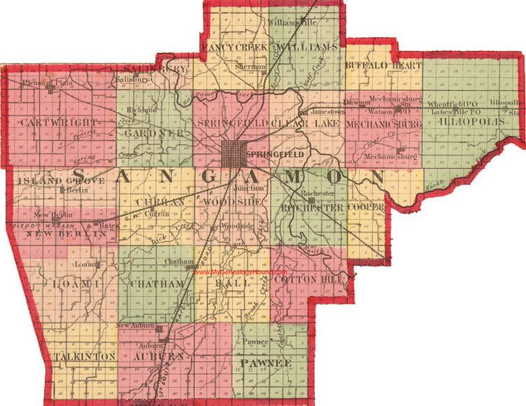
Map of Sangamon County, IL, USA
Sangamon County is included in the Springfield, IL Metropolitan Statistical Area.
History
Sangamon County was formed in 1821 out of Madison and Bond counties. The county was named for the Sangamon River, which runs through it. The origin of the name of the river is unknown; among several explanations is the theory that is comes from the Pottawatomie word Sain-guee-mon (pronounced "sang gä mun") meaning "where there is plenty to eat." Published histories of neighboring Menard County (formed from Sangamon County) suggest that the name was first given to the river by the French explorers of the late 17th century as they passed through the region. The river was named to honor "St. Gamo", or Saint Gamo, an 8th-century French Benedictine monk. The French pronunciation "San-Gamo" is the legacy.
Prior to being elected President of the United States, Abraham Lincoln represented Sangamon County in the Illinois Legislature. Lincoln, along with several other legislators, was instrumental in securing the Sangamon County seat, Springfield, as the state's capital. Sangamon County was also among the area represented by Lincoln when he served in the US House of Representatives. Another legislator who represented Sangamon County was Colonel Edmund Dick Taylor, also known as "Father of the Greenback". The prominent financiers and industrialists Jacob Bunn and John Whitfield Bunn were based in Springfield, Sangamon County, Illinois, as well as in Chicago, during the nineteenth century and the early twentieth century. The careers of these men and the people with whom they collaborated helped to shape much of the history and development of Sangamon County, Illinois.
Geography
According to the U.S. Census Bureau, the county has a total area of 877 square miles (2,270 km2), of which 868 square miles (2,250 km2) is land and 8.7 square miles (23 km2) (1.0%) is water.
Climate and weather
In recent years, average temperatures in the county seat of Springfield have ranged from a low of 17 °F (−8 °C) in January to a high of 87 °F (31 °C) in July, although a record low of −24 °F (−31 °C) was recorded in February 1905 and a record high of 112 °F (44 °C) was recorded in July 1954. Average monthly precipitation ranged from 1.62 inches (41 mm) in January to 4.06 inches (103 mm) in May.
Major highways
National protected areas
State protected areas
Demographics
As of the 2010 United States Census, there were 197,465 people, 82,986 households, and 51,376 families residing in the county. The population density was 227.4 inhabitants per square mile (87.8/km2). There were 89,901 housing units at an average density of 103.5 per square mile (40.0/km2). The racial makeup of the county was 83.6% white, 11.8% black or African American, 1.6% Asian, 0.2% American Indian, 0.5% from other races, and 2.2% from two or more races. Those of Hispanic or Latino origin made up 1.8% of the population. In terms of ancestry, 29.4% were German, 14.8% were Irish, 12.1% were English, 9.5% were American, and 6.3% were Italian.
Of the 82,986 households, 30.4% had children under the age of 18 living with them, 44.4% were married couples living together, 13.2% had a female householder with no husband present, 38.1% were non-families, and 31.8% of all households were made up of individuals. The average household size was 2.33 and the average family size was 2.94. The median age was 39.2 years.
The median income for a household in the county was $52,232 and the median income for a family was $66,917. Males had a median income of $48,324 versus $36,691 for females. The per capita income for the county was $28,394. About 9.9% of families and 13.4% of the population were below the poverty line, including 19.7% of those under age 18 and 7.3% of those age 65 or over.
Government
Sangamon County is governed by a 29-member board. Each member of the board is elected from a separate district.
Other elected officials include:
Cities
Townships
Sangamon County is divided into these townships: