
- elevation 1,299 ft (396 m) Length 66 km Basin area 1,305 km² | - elevation 887 ft (270 m) Basin area 1,305 km² | |
 | ||
Mouths | ||
Sandy Creek is a tributary of the Tuscarawas River, 41.3 miles (66.5 km) long, in northeastern Ohio in the United States. Via the Tuscarawas, Muskingum and Ohio Rivers, it is part of the watershed of the Mississippi River, draining an area of 503 square miles (1,303 km²).
Contents
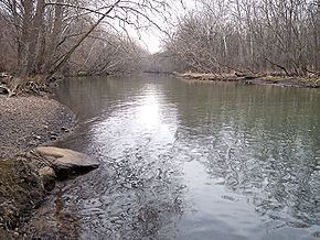
Map of Sandy Creek, Bethlehem Township, OH, USA
Sandy Creek rises in Hanover Township, approximately two miles (3 km) northeast of Hanoverton in western Columbiana County and flows generally west-southwestwardly through northwestern Carroll County, southeastern Stark County and northeastern Tuscarawas County, past the communities of Kensington, Minerva, Malvern, Waynesburg and Magnolia. It joins the Tuscarawas River from the east in Bethlehem Township in Stark County, approximately one mile (2 km) northeast of Bolivar. At Minerva, it collects the Still Fork. At Waynesburg it collects a short stream known as Little Sandy Creek. In Sandyville, Tuscarawas County it collects Nimishillen Creek, which drains the city of Canton.
A dry dam, Bolivar Dam, constructed by the U.S. Army Corps of Engineers, spans the creek near its mouth.
Flow rateEdit
At the United States Geological Survey's stream gauge in Waynesburg, the annual mean flow of the river between 1939 and 2005 was 278 ft³/s (8 m³/s). The highest recorded flow during the period was 15,000 ft³/s (425 m³/s) on January 22, 1959. The lowest recorded flow was 6.9 ft³/s (0 m³/s) on an unspecified date.
Variant namesEdit
According to the Geographic Names Information System, Sandy Creek has also been known historically as: