
- elevation 1,180 ft (360 m) Basin area 184.9 km² | - elevation 1,027 ft (313 m) | |
 | ||
- location Minerva, Carroll County | ||
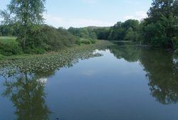
Still Fork is a tributary of the Sandy Creek, 16.1 miles (26 km) long, in eastern Ohio in the United States. Via the Sandy Creek, Tuscarawas, Muskingum and Ohio Rivers, it is part of the watershed of the Mississippi River, draining an area of 71.4 square miles (185 km2) in Carroll County, Ohio. The source is at 1,180 feet (360 m) and the mouth is at 1,027 feet (313 m)., with an average gradient of only 0.2%. From its source in eastern Carroll County the creek flows northwest through Fox, Washington, Augusta, and Brown Townships before reaching its mouth in Minerva, Ohio. The Ohi-Rail Corporation (OHIC) and Arbor road are situated in the creeks valley over most of its length.
Contents
Map of Still Fork, Ohio, USA
Near Augusta the creek flows through a rural Amish community, and downstream of Ohio State Route 9 is the unincorporated community of Pattersonville. Mechanicstown and Norristown are the only other named communities in the watershed.
Variant namesEdit
According to the Geographic Names Information System, Still Fork has had no other known names.
Still Fork of Sandy Navigation CompanyEdit
On February 15, 1837, the General Assembly of the state of Ohio enacted AN ACT to incorporate the Still Fork of Sandy Navigation Company. This act authorized seven named Carroll county men to form the company to “…locate, make, construct, and forever maintain, a navigable canal or slack-water navigation, commencing on the land of William Croxton, where the New Lisbon-Carrollton road crosses said Still Fork of Sandy, and thence with the general course of said stream, to intersect the Sandy and Beaver Canal, at the town of Pekin, in said county of Carroll…with the full power to emyloy (sic), as reservoirs or feeders, all streams or ponds over or near which such canal or slack-water navigation may pass.” The company was capitalized at $65,000 in $25 shares to be sold to individuals only. William Croxton’s land was in section 11 of Washington Township, a short distance up Friday Creek from the main branch of Still Fork, and present day county road 71 was the road between Carrollton and Lisbon.