
Elevation 4,170 ft (1,270 m) | ||
 | ||
Mountains Similar | ||
Sandwich range training run august 2011
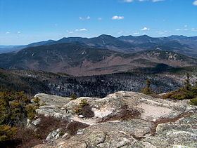
The Sandwich Range is located in the White Mountains of New Hampshire in the United States, north of the Lakes Region and south of the Kancamagus Highway. Although the range is not outstanding for its elevation, it is very rugged and has excellent views of the surrounding lakes, mountains, and forests.
Contents
- Sandwich range training run august 2011
- Map of Sandwich Range Waterville Valley NH 03259 USA
- Sandwich range wilderness redlining 11 10 2012
- SummitsEdit
- References
Map of Sandwich Range, Waterville Valley, NH 03259, USA
The Sandwich Range extends east-west about 30 miles from Conway, New Hampshire on the Saco River to Campton on the Pemigewasset River. The Kancamagus Highway runs along the north side of the mountains, from Conway to North Woodstock. The highest peak in the range is Mount Tripyramid, with an elevation of 4,170 feet (1,270 m).
The east part of the range drains by various streams into the Saco River and thence into the Atlantic Ocean at Saco, Maine. The west part drains into the East Branch Pemigewasset River and Mad River, thence into the Pemigewasset, Merrimack and into the sea at Newburyport, Massachusetts.
The range shares its name with the town of Sandwich, situated at the range's western end.
Sandwich range wilderness redlining 11 10 2012
SummitsEdit
From northeast to southwest, the range's principal summits include:
The summits marked with an asterisk (*) are included on the Appalachian Mountain Club's peak-bagging list of "Four-thousand footers" in New Hampshire.