
Country United States Time zone Eastern (EST) (UTC-5) Elevation 225 m Population 528 (2010) | ZIP code 03262 Area 230 ha Area code Area code 603 | |
 | ||
Restaurants Woodstock Inn Station & Brewery, Cafe Lafayette Dinner Tr, Rustic River Restaurant, Truants' Taverne, Clement Room Grille | ||
Nh alive lost river in north woodstock new hampshire
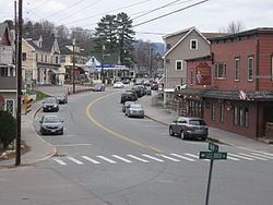
North Woodstock is a census-designated place in the town of Woodstock in Grafton County, New Hampshire. It had a population of 528 at the 2010 census.
Contents
- Nh alive lost river in north woodstock new hampshire
- Map of North Woodstock Woodstock NH USA
- References
Map of North Woodstock, Woodstock, NH, USA
It is located along the northern boundary of the town of Woodstock, adjacent to Lincoln, New Hampshire. The village is centered on the intersection of U.S. Route 3 (Main St.) and New Hampshire Route 112 (Lost River Rd./Kancamagus Highway). Interstate 93 passes through the east portion of the village. The Pemigewasset River flows past the center of North Woodstock, joined by the East Branch of the Pemigewasset and Moosilauke Brook at the southern limits of the village.
References
North Woodstock, New Hampshire Wikipedia(Text) CC BY-SA