
Country United States ZIP codes 92314, 92386 Elevation 2,064 m Population 12,304 (1 Apr 2010) | State California FIPS code 06-06406 Area 82.8 km² Area code 909 | |
 | ||
Big Bear City is an unincorporated town in San Bernardino County, California, United States along the east shore of Big Bear Lake and surrounded by the San Bernardino National Forest. It is located 27 miles (43 km) northeast of the city of San Bernardino, and immediately east of the incorporated city of Big Bear Lake. Its population was 12,304 at the 2010 census, up from 5,779 at the 2000 census. The makeup of Big Bear City is mostly residential with smaller houses and cabins laid out in typical square block fashion.
Contents
Map of Big Bear, CA 92314, USA
Despite the name, Big Bear City is not an incorporated city, and should not be confused with the adjacent incorporated city of Big Bear Lake.
Geography
Big Bear City is its own census-designated place. According to the United States Census Bureau, the CDP has a total area of 32.0 square miles (83 km2), 99.95% of it land and 0.05% of it water.
The nearby ski resorts consist of Snow Summit and Bear Mountain, usually shortened to "Bear" by locals.
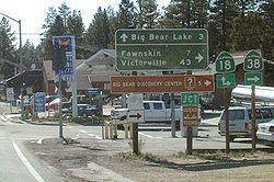
Most of the town and the business district are centered on Big Bear Boulevard. Its limits are defined on the West by Division Road and on the east by the left turn at Highway 38, which goes to Redlands and Highway 18 which goes to downtown San Bernardino. Though its south boundary is loosely defined by the residential boundary, the north side is defined by North Shore Road. The east-west postal divider of Big Bear City is Green Way Drive. It is here that Highway 18 (Big Bear Boulevard) turns north and crosses over to North Shore Drive heading east toward Lucerne Valley, and Highway 38 coming from the east turns north to North Shore and heads west to Big Bear Dam.
Sugarloaf is a large residential area that lies to the south of Big Bear City.
It is often the location of altitude training for many Boxers and Mixed martial arts contestants such as Oscar De La Hoya, Shane Mosley, and Tito Ortiz.
2010
The 2010 United States Census reported that Big Bear City had a population of 12,304. The population density was 384.8 people per square mile (148.6/km²). The racial makeup of Big Bear City was 10,252 (83.3%) White (75.8% Non-Hispanic White), 83 (0.7%) African American, 202 (1.6%) Native American, 103 (0.8%) Asian, 31 (0.3%) Pacific Islander, 1,089 (8.9%) from other races, and 544 (4.4%) from two or more races. Hispanic or Latino of any race were 2,323 persons (18.9%).
The Census reported that 12,286 people (99.9% of the population) lived in households, 18 (0.1%) lived in non-institutionalized group quarters, and 0 (0%) were institutionalized.
There were 5,011 households, out of which 1,546 (30.9%) had children under the age of 18 living in them, 2,435 (48.6%) were opposite-sex married couples living together, 567 (11.3%) had a female householder with no husband present, 308 (6.1%) had a male householder with no wife present. There were 313 (6.2%) unmarried opposite-sex partnerships, and 73 (1.5%) same-sex married couples or partnerships. 1,335 households (26.6%) were made up of individuals and 450 (9.0%) had someone living alone who was 65 years of age or older. The average household size was 2.45. There were 3,310 families (66.1% of all households); the average family size was 2.94.
The population was spread out with 2,865 people (23.3%) under the age of 18, 917 people (7.5%) aged 18 to 24, 2,695 people (21.9%) aged 25 to 44, 4,060 people (33.0%) aged 45 to 64, and 1,767 people (14.4%) who were 65 years of age or older. The median age was 42.9 years. For every 100 females there were 102.7 males. For every 100 females age 18 and over, there were 100.4 males.
There were 12,226 housing units at an average density of 382.4 per square mile (147.6/km²), of which 3,409 (68.0%) were owner-occupied, and 1,602 (32.0%) were occupied by renters. The homeowner vacancy rate was 9.0%; the rental vacancy rate was 14.0%. 7,854 people (63.8% of the population) lived in owner-occupied housing units and 4,432 people (36.0%) lived in rental housing units.
According to the 2010 United States Census, Big Bear City had a median household income of $42,957, with 20.9% of the population living below the federal poverty line.
2000
As of the census of 2000, there were 5,779 people, 2,290 households, and 1,603 families residing in the CDP. The population density was 1,665.1 inhabitants per square mile (643.0/km²). There were 4,801 housing units at an average density of 1,383.3 per square mile (534.2/km²). The racial makeup of the CDP was 89.1% White, 0.6% African American, 1.3% Native American, 1.5% Asian, 0.1% Pacific Islander, 3.8% from other races, and 4.7% from two or more races. Hispanic or Latino of any race were 12.9% of the population.
There were 2,290 households out of which 32.3% had children under the age of 18 living with them, 54.1% were married couples living together, 10.8% had a female householder with no husband present, and 30.0% were non-families. 23.6% of all households were made up of individuals and 8.9% had someone living alone who was 65 years of age or older. The average household size was 2.5 and the average family size was 3.0.
In the CDP, the population was spread out with 26.5% under the age of 18, 6.9% from 18 to 24, 27.3% from 25 to 44, 25.9% from 45 to 64, and 13.3% who were 65 years of age or older. The median age was 39 years. For every 100 females there were 98.2 males. For every 100 females age 18 and over, there were 96.0 males.
The median income for a household in the CDP was $35,615, and the median income for a family was $42,995. Males had a median income of $33,994 versus $20,844 for females. The per capita income for the CDP was $19,301. About 5.1% of families and 6.6% of the population were below the poverty line, including 10.6% of those under age 18 and 1.2% of those age 65 or over.
Government
In the California State Legislature, Big Bear City is in the 23rd Senate District, represented by Republican Mike Morrell, and in the 33rd Assembly District, represented by Republican Jay Obernolte.
In the United States House of Representatives, Big Bear City is in California's 8th congressional district, represented by Republican Paul Cook.
Transportation
Big Bear City Airport is a general aviation airport in Big Bear City. There are no commercial air services to this airport, although at least two airlines, including Trans World Airlines, have served Big Bear in the past. This airport may also be used for medical evacuations, and as a base for forest-fighting aircraft when there are fires close by.