
 | ||
Diving the salish sea winter 2016
The Salish Sea (/ˈseɪlɪʃ/ SAY-lish) is the intricate network of coastal waterways that includes the southwestern portion of the Canadian province of British Columbia and the northwestern portion of the U.S. state of Washington. Its major bodies of water are the Strait of Georgia, the Strait of Juan de Fuca, and Puget Sound. It reaches from Desolation Sound at the north end of the Strait of Georgia to Oakland Bay at the head of Hammersley Inlet at the south end of Puget Sound. The inland waterways of the Salish Sea are partially separated from the open Pacific Ocean by Vancouver Island and the Olympic Peninsula, and are thus partially shielded from Pacific Ocean storms. Major port cities on the Salish Sea include Vancouver, Seattle, Tacoma, Bellingham, Port Angeles and Victoria. Much of the coast is part of a megalopolis stretching from West Vancouver, British Columbia to Olympia, Washington.
Contents
- Diving the salish sea winter 2016
- Map of Salish Sea
- Sailing seattle the salish sea san juan and gulf islands
- Definition
- Origin of the term
- Coast Salish peoples
- Official recognition
- Opposition
- Other names
- Fish
- References
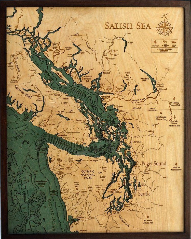
Map of Salish Sea
Sailing seattle the salish sea san juan and gulf islands
Definition
The Salish Sea includes the Strait of Juan de Fuca, the Strait of Georgia, Puget Sound, and all their connecting channels and adjoining waters, such as Haro Strait, Rosario Strait, Bellingham Bay, Hood Canal, and the waters around and between the San Juan Islands in the U.S. state of Washington and the Gulf Islands in British Columbia, Canada. The western boundary is the entrance to the Strait of Juan de Fuca, defined as a line between Cape Flattery and Carmanah Point. The southern boundary is the southern end of Puget Sound. The northern boundary reaches just beyond the northern end of the Strait of Georgia to include waters that experience the floodstream or tidal surge from the south: Discovery Passage south of Seymour Narrows, Sutil Channel south of Penn Islands, Lewis Channel (between Cortes and West Redonda Island), Waddington Channel (between West Redonda and East Redonda Island), and Pendrell Sound, Desolation Sound, and the southern portion of Homfray Channel (between East Redonda Island and the mainland). These boundaries were based on the 2002 "Georgia Basin–Puget Sound Ecosystem Indicators Report". The total extent of the Salish Sea is about 18,000 square kilometres (6,900 sq mi).
Origin of the term
The first known use of the term Salish Sea was in 1988, when marine biologist Bert Webber from Bellingham, Washington, created the name for the combined waters in the region with the intention to complement the names Georgia Strait, Puget Sound, and Strait of Juan de Fuca, not replace them. The adoption of the term, he said, would raise consciousness about taking care of the region's waters and ecosystems. Webber's efforts are credited with the official recognition of the term in Canada and the U.S.
Coast Salish peoples
The Coast Salish are the indigenous peoples who live in southwest British Columbia and northwest Washington along the Salish Sea and share a common linguistic and cultural origin. The Coast Salish are seen as one of the main cultural and linguistic branches of a larger group known as Salishan or Salish. Five divisions of the Salish language family are recognized, with Coast Salish and Interior Salish being the primary two. The Salish family consists of 23 separate languages. European and American explorers first encountered Salishan people along the Pacific Northwest coast in the late 18th century. The first detailed information was obtained by the Lewis and Clark Expedition of 1804-1806. The term "Salish" was originally applied only to the Interior Salish Flathead tribe living in the region of Flathead Lake, Montana. By the mid-20th century, it had been extended to cover all people speaking a similar language. The Flathead Nation continues to refer to their language and culture as Salish. A variant name for Flathead Lake is "Selish Lake". The name Salish Sea was coined only in the late 20th century. No overarching title exists for this area or even a commonly shared name for any of the waterbodies in any of the Coast Salish languages.
The waterways of the Salish Sea were important trade routes for the Coast Salish, and they remain a source of food and other resources for the indigenous peoples. The basin includes territory of not only Coast Salish peoples, but also the Northern Wakashan Kwakwaka'wakw and Southern Wakashan peoples (the Nuu-chah-nulth, Makah, and Ditidaht) and, formerly, that of the Chimakum (a Chimakuan people related to the Quileute who no longer exist as recognizable group, having been wiped out by the Suquamish and others in the 19th century).
Official recognition
In March 2008, the Chemainus First Nation proposed renaming the strait the "Salish Sea," an idea that reportedly met with approval by B.C.'s Aboriginal Relations Minister Mike de Jong, who pledged to put it before the B.C. cabinet for discussion. Making the name "Salish Sea" official required a formal application to the Geographical Names Board of Canada. A parallel American movement promoting the name had a different definition, combining of the Strait of Juan de Fuca and Puget Sound as well as the Strait of Georgia and related waters under the name Salish Sea.
In August 2009, the British Columbia Geographical Names Office approved a resolution recommending that the Geographical Names Board of Canada adopt the name Salish Sea contingent on approval by the United States Board on Geographic Names. The name was endorsed by the Washington State Board on Geographic Names in late October, 2009. It was approved by the United States Board on Geographic Names on November 12, 2009, and by the British Columbia Geographical Names Office in February 2010. The French name Mer de Salish is also official in Canada.
Opposition
Opponents to the Salish Sea designation assert that it is really a series of interconnected straits, sounds and inlets. Others oppose it for historical reasons and question the validity of the term "Salish". Despite these objections, the geographic boards of both Canada and the United States have officially recognized the name since the year 2010.
Other names
The region encompassing these waterways is or was also known variously as the Georgia–Puget or Puget–Georgia Basin, or in the singular as the Georgia Depression, the Georgia Basin or Puget Sound et al. The Canadian half of the region was originally named in 1792 by George Vancouver, and often remains referred to as the Gulf of Georgia, a term which encompasses the Strait of Georgia and all other waters peripheral to it, as well as to the communities lining its shores or on its islands. Like the term "Puget Sound," the terms "Georgia Strait" and "Gulf of Georgia" refer to the general region as well as the body of water.
Fish
Scientists have identified 253 fish species observed in marine or brackish waters of the Salish Sea ecosystem. These 253 species, encompassing one myxinid, two petromyzontids, 18 chondrichthyans, two chondrosteans, and 230 teleosts, are contained within 78 families and 31 orders.