
Basin countries United States Surface elevation 882 m | Area 510.2 km² Length 43.9 km | |
 | ||
Primary inflows Catchment area 8,587 sq mi (22,240 km) Similar | ||
Flathead lake
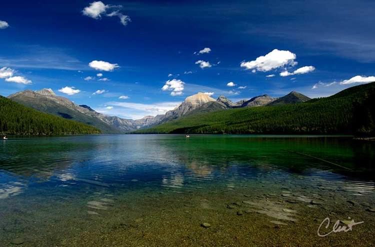
Flathead Lake (Salish: člq̓etkʷ ) is the largest natural freshwater lake by surface area that is west of the Mississippi River in the contiguous United States, if one takes Red Lake and Lake of the Woods to be north of the Mississippi River, rather than west of the river.
Contents
- Flathead lake
- Map of Flathead Lake Montana USA
- Averill s flathead lake lodge montana fun ranch activities
- GeographyEdit
- HistoryEdit
- GeologyEdit
- References
Map of Flathead Lake, Montana, USA
With a surface area of between 191.5 sq mi (496 km2) and 197 sq mi (510 km2), Flathead Lake is slightly larger in surface area than Lake Tahoe, but it is much smaller in volume.
The lake is a remnant of the ancient, massive glacial dammed lake, Lake Missoula of the era of the last interglacial. Flathead Lake is 27.3 mi (43.9 km) long and up to 15.5 mi (24.9 km) wide. Flathead Lake has a maximum depth of 370.7 ft (113.0 m), and an average of 164.7 ft (50.2 m). This makes Flathead Lake deeper than the average depths of the Yellow Sea or the Persian Gulf. Polson Bay, at the lake's outlet, was raised 10 ft (3.0 m) by Kerr Dam. It is one of the cleanest lakes in the populated world for its size and type.
Averill s flathead lake lodge montana fun ranch activities
GeographyEdit
Located in the northwest corner of the state of Montana, 7 miles (11 km) south of Kalispell, it is approximately 30 miles (50 km) long and 16 miles (25 km) wide, covering 191.5 square miles (495.9 km²), making it approximate in size to Minnesota's Mille Lacs Lake and half the area of San Francisco Bay (main bay). Flathead Lake is 30 miles (48 km) southwest of Glacier National Park and is flanked by two scenic highways, which wind along its curving shoreline. On the west side is U.S. Route 93, and on the east, is Route 35.
The lake is bordered on its eastern shore by the Mission Mountains and on the west by the Salish Mountains. The Flathead valley was formed by the glacial damming of the Flathead River and sustains a remarkably mild climate for a region located this far north and inland; the Pacific Ocean is almost 400 miles to the west. The mild climate allows for cherry orchards on the east shore and vineyards for wine production on the west shore. There are also apple, pear and plum orchards around the lake as well as vegetables, hay, honey, nursery tree, Christmas tree, sod/turf and wheat production bordering or near the lake.
HistoryEdit
Once known as "Salish Lake", this body of water takes its name from the Salish (Flathead) Indians who live at the southern end of the lake on the Flathead Indian Reservation. Kerr Dam, near Polson, regulates the lake's water level and provides hydroelectric power and water for irrigation. The lake has an irregularly-shaped shoreline and a dozen small islands, the largest of which is a state park called Wild Horse Island. These islands cover 5.5 square miles (14.2 square kilometers). Besides the Flathead River, the Swan River (known also as the Bigfork River where it enters the lake) is the lake's other major tributary. The lake is inhabited by the native bull trout and cutthroat trout, as well as the non-native lake trout, yellow perch, and lake whitefish. Local residents have reported sighting other aquatic fauna in the lake as well, such as sturgeon and the Flathead Lake Monster.
The opossum shrimp, Mysis diluviana, were introduced by Montana Department of Fish, Wildlife and Parks in the Flathead drainage basin to encourage production of larger kokanee salmon and wound up in Flathead Lake. Lake trout had been introduced 80 years prior but remained at low densities until nonnative Mysis became established. The bottom-dwelling mysids eliminated a recruitment bottleneck for lake trout by providing a deep water source of food where little was available previously. Lake trout subsequently flourished on mysids and this voracious piscivore now dominates the lake fishery; formerly abundant kokanee were extirpated, and native bull and westslope cutthroat trout are imperiled. Predation by Mysis shifted zooplankton and phytoplankton community size structure. Bayesian change point analysis of primary productivity (27-y time series) showed a significant step increase of 55 mg C m−2 d−1 (i.e., 21% rise) concurrent with the mysid invasion, but little trend before or after despite increasing nutrient loading. Mysis facilitated predation by lake trout and indirectly caused the collapse of kokanee, redirecting energy flow through the ecosystem that would otherwise have been available to other top predators (bald eagles).
GeologyEdit
Flathead Lake lies at the southern end of a geological feature called the Rocky Mountain Trench. The trench, which formed with the Rocky Mountains, extends north into the southern Yukon as a straight, steep valley, which also holds the headwaters of the Columbia River. During the last ice age this trench was filled by an enormous glacier. As the glacier moved southward it carved out the trench. The Polson Moraine, near present-day Polson, Montana, marks the southernmost extent of the glacier during the last ice age and thus is the site of the glacier's terminal moraine.
The large size of the Polson Moraine indicates that the glacier stalled here for many years before retreating. As the climate warmed, a portion of the glacier in the Mission Valley receded more slowly than the main body, which kept the lake basin from being filled with sediment. Eventually this ice also melted, forming a lake behind the moraine. Once the water reached the top of this moraine dam, it began to cut a channel through it. Most moraine dammed lakes drain quickly because water cuts entirely through the moraine. However, Flathead Lake remains because a bedrock hill buried underneath the Polson Moraine prevented the moraine from being completely cut through so the meltwater never completely drained.
At one time, probably when the valley was partially filled by a glacier, the level of Flathead Lake was about 500 feet (150 m) higher and drained through the valley west of Elmo, Montana, which is at the end of Big Arm Bay, bottom center in the aerial photo above. Water carved out a wide, flat-bottomed pass with a deeper, narrow channel at the south edge of the pass. The deeper channel and traces of the dry riverbed are still visible from Route 28.