Max. length 100 km (62 mi) Surface area 1,600 km (618 sq mi) Surface elevation 3,460 m | Max. width 50 km (31 mi) Area 1,600 km² Cities Tolar Grande | |
 | ||
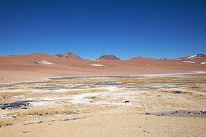
Salar de Arizaro is a large salt flat of the Andes in north-western Argentina, bordering with Chile. It is located between the villages of Tolar Grande and Caipe and near Mina La Casualidad, in Los Andes Department, Salta Province.
Contents
Map of Lago Salar de Arizaro, Salta Province, Argentina
Overview
Located in the central-western area of the Puna de Atacama, it covers an area of 1,600 km². Per extension, the Salar de Arizaro is the 6th largest salt flat in the World and the 2nd largest in Argentina after the Salinas Grandes.
The salar area is mined for metallic and non-metallic resources, as it is rich in salt, marble, iron, copper and onyx.
The nearest salt flats are the ones of Antofalla, Hombre Muerto (both in north of Catamarca Province), Pocitos (in the east) and the Salinas Grandes of Jujuy and Salta provinces.
The Salar de Arizaro is crossed in the middle by the Salta–Antofagasta railway and by the Provincial Route 27 (part of the former RN 59). A particular characteristic of it is a conical hill named Cerro Cono (or Cono de Arita), a sandstone-formation.
