
Website Official website | ||
 | ||
Siaha District is one of the eight districts of Mizoram state in India. The district is bounded on the north and northwest by Lunglei district, on the west by Lawngtlai District and on the south and east by Myanmar. The district occupies an area of 1399.9 km². Saiha town is the administrative headquarters of the district. The population had decreased from 60,823 (in 2001 census) to 56,574 (in 2011 census). It is the least populous district of Mizoram (out of 8).
Contents
Map of Saiha, Mizoram
History
Saiha District was formerly part of Chhimtuipui District. In 1998 when Chhimtuipui District was split in half, the half that became Saiha District was briefly called by the old name Chhimtuipui District.
Geography
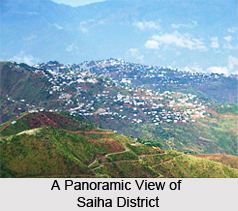
Saiha is the administrative headquarters of Saiha district. It is the third largest town in Mizoram after Aizawl, the state capital and Lunglei. Tuipang, Sangau, Phura and Bualpui NG are the other main towns in Saiha district.
Economy
In 2006 the Ministry of Panchayati Raj named Saiha one of the country's 250 most backward districts (out of a total of 640). It is one of the two districts in Mizoram currently receiving funds from the Backward Regions Grant Fund Programme (BRGF).
Divisions
The district has 3 R.D. Blocks, Saiha also known as Siaha, Sangau and Tuipang also known as Tipa V. The 3 assembly constituencies in this district are Saiha, Sangau and Tuipang.
Demographics
According to the 2011 census Saiha district has a population of 56,574, roughly equal to the island of Greenland. This gives it a ranking of 628th in India (out of a total of 640). The district has a population density of 40 inhabitants per square kilometre (100/sq mi). Its population growth rate over the decade 2001-2011 was -7.34%; the only district in Mizoram to have decreased population. Saiha has a sex ratio of 979 females for every 1000 males, and a literacy rate of 90.01%.
The majority of the district inhabitants are Mara people, who also have an autonomous district council called Mara Autonomous District Council composed of the two R.D. Blocks of Saiha and Tuipang; the Lai people, on the other hand, are the main inhabitants of Sangau R.B block, which is part of the Lai Autonomous District Council.
Flora and fauna
In 1997 Saiha district became home to Phawngpui Blue Mountain National Park, which has an area of 50 km2 (19.3 sq mi).