
- elevation 782 m (2,566 ft) Source Dhebar Lake | Length 371 km | |
 | ||
- left Wakal river, Sei Nadi, Harnav River, Hathmati River, Watrak River, Madhumati River. - average 120 m/s (4,238 cu ft/s) Bridges Ellis Bridge, Nehru Bridge | ||
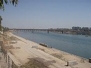
Sabarmati riverfront places to visit in ahmedabad gujarat
The Sabarmati river is one of the major west-flowing rivers in India. It originates in the Aravalli Range of the Udaipur District of Rajasthan and meets the Gulf of Cambay of Arabian Sea after travelling 371 km in a south-westerly direction across Rajasthan and Gujarat. 48 km of the river length is in Rajasthan, while 323 km is in Gujarat.
Contents
- Sabarmati riverfront places to visit in ahmedabad gujarat
- Map of Sabarmati River
- Sabarmati river ahmedabad best place of ahmedabad gujarat india
- Basin
- History
- Dams
- Dharoi Dam
- References
Map of Sabarmati River
Sabarmati river ahmedabad best place of ahmedabad gujarat india
Basin
The Sabarmati basin has a maximum length of 300 km. and maximum width of 105 km. The total catchment area of the basin is 21674 km2 out of which, 4124 km2 lies in Rajasthan State and the remaining 18550 km2 in Gujarat.
Sabarmati river basin is situated in the mid-southern part of Rajasthan. To its east lie the Banas and Mahi Basins, to its north the Luni Basin and to its west the West Banas Basin. Its southern boundary is the border with Gujarat State. The Sabarmati river basin extends over parts of Udaipur, Sirohi, Pali and Dungarpur Districts. Orthographically, the western part of the Basin is marked by hilly terrain belonging to the Aravali Range. East of the hills lies a narrow alluvial plain with a gentle eastward slope.
The major tributaries are the Sei, Wakal, Watrak, Shedhi, Harnav, Guhai, Hathmati, Khari, Meshwo, Mazam and Mohar. Average annual water availability in the Sabarmati basin is 308 m3/capita, which is significantly lower than the national average of 1545 m3/capita.
History
The origin legend is that Shiva brought the goddess Ganga to Gujarat and that caused the Sabarmati to come into being.
Ahmedabad and Gandhinagar, the commercial and political capitals of Gujarat respectively, were established on the banks of Sabarmati river. The legend is that Sultan Ahmed Shah of Gujarat, resting on the bank of Sabarmati, was inspired by the courage of a rabbit chasing a dog to the extent of establishing Ahmedabad in 1411. The soils of the Sabarmati area on the banks of the river are rich.
During India's independence struggle, Mahatma Gandhi established Sabarmati Ashram as his home on the banks of this river.
The National Water Quality Programme led by Central Pollution Control Board (CPCB) positions Sabarmati River as one of the most polluted rivers in India.
Dams
There are several reservoirs on Sabarmati and its tributaries. The Dharoi dam is located on the main river. Hathmati dam, Harnav dam and Guhai dam are located on the tributaries meeting the main river upstream of Ahmedabad while Meshvo reservoir, Meshvo pick-up weir, Mazam dam and Watrak dam are located on tributaries meeting downstream. The Kalpasar is planned project in the Gulf of Khambhat.
Dharoi Dam
The area covering upper sub-basin and the catchment of the main river up to Dharoi dam is designated as Dharoi sub-basin. Constructed in 1978, Dharoi dam is located about 165 km upstream Ahmedabad in village Dharoi of Mehsana district. This covers drainage area of the main river up to Dharoi dam. Catchment area of the sub basin is 5540 km2, out of which about 2,640 km2 lies in Gujarat state.