
Length 24 km (14.9 mi) Highest elevation 725 m (2,379 ft) Concelhos (Municipalities) São Vicente Area 227 km² Population 79,374 (2010) | Width 16 km (9.9 mi) Highest point Monte Verde | |
 | ||
Island groups Barlavento Islands, Cape Verde archipelago Points of interest Laginha, Palácio do Povo, Monte Verde - Cape Ver, Praia Grande - Cape Ver, Fortim do Rei | ||
São Vicente (Portuguese for "Saint Vincent"), also Son Visent or Son Sent in Cape Verdean Creole, is one of the Barlavento islands of Cape Verde. It is located between the islands of Santo Antão and Santa Luzia, with the Canal de São Vicente separating it from Santo Antão.
Contents
- Map of SC3A3o Vicente Cape Verde
- Geography
- Climate
- Geographical features
- History
- Population
- Economy
- Education
- Educational institutions
- Other institutions and observatories
- Language
- Persons
- Transportation
- Culture
- Sports
- Twin towns and sister cities
- References
Map of S%C3%A3o Vicente, Cape Verde
Geography
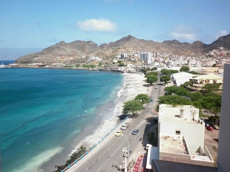
The island is roughly rectangular in shape with a surface area of ca. 227 square kilometres (88 square miles). From east to west it measures 24 kilometres (15 miles) and from north to south no more than 16 kilometres (9.9 miles). The terrain includes mountains in the west, the southwest, the south, the east-central and the north. The area is flat in the north-central and central parts, the eastern part south of Calhau, and the northern part in the Baía das Gatas area. The urban area of Mindelo is in the northern part.
The island, of volcanic origin, is fairly flat. Its highest point is Monte Verde (green mountain), located in the northeast-central part with an altitude of 725 metres (2,379 feet). Although very eroded, some craters still remain, in particular near the bay of Mindelo. Other mountains include Monte Cara and Topona.
A small islet, Ilheu dos Passaros, is less than one nautical mile off the coast north of Porto Grande Bay off Mindelo, the island being one of five that have surrounding islets.
Until the mid-20th century, trees were scarce in the island, and most of the island remains deforested. Most of the wide valleys and smaller dales have become forested, particularly in the middle of the island.
Climate
São Vicente enjoys a very rare mild and dry tropical climate (Köppen–Geiger classification As), much like Santa Cruz de Tenerife or Las Palmas on the Canary Islands, but somewhat warmer during winter months. The average annual temperature in Mindelo is 23.2 °C (73.8 °F) which is two degrees more than in Santa Cruz de Tenerife. The island is very arid, with only 80 to 130 mm (3.15–5.12 inches) of annual rainfall, somewhat higher only near the tops of the few mountains. These rare climate conditions are due to its position far off the west African coast and because Cape Verde is in the middle of the cold Canary Current. The ocean water temperature every year is between 22 °C (72 °F) and 25 °C (77 °F). There are two seasons: December through July is mainly dry, cool and windy, while August through November is a wetter and warmer season.
Geographical features
In clockwise order:
History
During the last ice age there was a larger island, which has been called the "Northwestern Island", including what is now São Vicente, Santo Antão, Santa Luzia and two other islets, with an area of about 1,500 km2 (579 sq mi). About 2,000 years ago, flooding broke up this island into the three larger and several smaller islands of today.
São Vicente was discovered on Saint Vincent's Day (January 22), 1462. The island was granted to the Dukes of Viseu. It remained unpopulated, and eventually passed to Manuel I of Portugal.
Due to its lack of water, the island was initially used only as a cattle pasture by some proprietors of the neighboring island of Santo Antão. Pirates sometimes came to the natural harbour; fortifications were built in 1734 to protect British, French and Dutch pirates. The island remained practically uninhabited until 1795, when the area of Porto Grande Bay was settled. In the mid-19th century the original name of the island's first settlement was Nossa Senhora da Luz, the first church on the island; this is the name of a parish today. In 1819 the village was to be renamed to Leopoldinha after empress Maria Leopoldina of Austria, wife of Peter IV of Portugal, it was not renamed until 1838 when the name Mindelo was adopted, after a Portuguese military expedition that occurred in the beaches of Mindelo, Portugal during the Portuguese Civil War or the Wars of Liberation. The name "Mindelo de São Vicente" is sometimes used today by outsiders. The British, who were allied with Portugal, expanded most of the island's economy after Brazil declared independence in September 1822. It was only in 1838, when a coal deposit was established in Porto Grande to supply ships on Atlantic routes, that the population started to grow rapidly. It was the first island in Cape Verde to abolish slavery, São Nicolau and Santo Antão abolished it a year later. Telegraph lines were established in 1874 by the Western Telegraph Company, via Madeira, to connect with Recife, the capital of Pernambuco in Brazil. In 1886 the network was expanded to connect to other places, especially the southern and eastern parts of the British Empire. From the start of the 20th century the introduction of diesel ships made the coaling unnecessary; ships began to stop instead at Dakar and the Canary Islands, and the island economy declined; the island was particularly hard hit after the Great Depression until the late 1940s. This caused a rise of the independence movement; the economy remained in bad shape until Cape Verde became independent. The historic center of Mindelo has buildings from that date preserved into the present day. The Liceu Nacional Infante D. Henrique (now known as Escola de Jorge Barbosa), built in 1921, is out of colonial architecture, it had huge importance on the development of the rising nationalism of Cape Verde.
Due to the lack of rain and consequent lack of natural resources, the economy of São Vicente is based mainly on commerce and services.
Population
The population of São Vicente in the 2010 census was 79,374 of which 5,639 are rural. It is the second most populous island of Cape Verde. The annual population growth is around 1.3% (higher than the state (national) level of 1.2%). 92.6% of the population live in urban areas, higher than the Cape Verde's level of 61.8% and is the highest in all of Cape Verde. Life expectancy is 76 years, higher than some other parts of the world. The birth rate is 2.7% and infant mortality rate is 18 per 1000 live births (for comparison 103 in DR Congo, 55 in India, 27 in Turkey, 23 in Brazil, 16 in Russia, 4 in Finland).
The population grew in the 19th century, it later slowed, the growth between 1950 and 1960 only added over a thousand, immigration affected the population, Between 1960 and 2010, the population nearly quadrupled, in the first ten years, the population grew more than 50% and reached over 30,000, the population today is now over 80,000. Up until 1920, the island was the third most populated in the Barlavento archipelago. Santo Antão had been the second most populated Barlavento Island, but São Vicente overtook it in the early 1980s.
The majority of the population is young; 66% of the population is under the age of 30, and 8.6% of the population is over the age of 60. The island has 16,000 families, of which there are an average of 3,6 persons per household, lower than Cape Verde's level of 3,9 persons per household. 56% of the families live in houses, the other 30% live in poorly built houses.
In 2006 only about 11% of the families owned automobiles, which was 7.4% of Cape Verde's level.
Economy
The economy of the island was always based almost exclusively on commerce and services. Due to lack of rain, agriculture is at a subsistence level. Fishing has some relevance, but conditions prevent it from being more important, not only for the catch—lobster—but also for the associated industries: conserves, drying and salting of fish, and naval construction.
Porto Grande is the main port of Cape Verde, through which passes much of the country's imports. It has a terminal of containers, silos, and refrigeration units that make handling load overflow possible. There is also a modern seawater desalination plant, which provides water for public consumption and for naval shipyards.
In the industrial sector, the island presents an abundance of manpower, even though unskilled, resulting from the exodus of inhabitants of other islands to São Vicente. About 27% of the employed population is unskilled. Highly qualified employees—company executives, public administrators, and managers and directors—make up less than 2% of employees. It is distinguished, however, by a bigger participation of women in decision-making positions than the national average.
According to the 2010 census, the island of São Vicente has the largest unemployment rate of the country—14,8%—while the national average is 11%. Unemployment affects women more than men. The industrial park of the island—the Industrial Zone of the Lazareto—concentrates diverse types of manufacturing, essentially due to foreign investment, in the activities of footwear, confections, and fish processing.
The National Center of Workmanship of Mindelo supports local craftsmen in the production and commercialization of ceramic parts, articles made of coconut rinds, and necklaces of shells and rocks.
Many sports are practised in São Vicente, and many have spread to the remaining islands. The island is suitable for windsurfing; the beach of São Pedro is considered one of the best for windsurfing, as shown by the many world-class champions of the sport. Cycling, walking trails and horseback riding are ways to explore the island. São Vicente has an excellent 18-hole golf course. For these reasons, tourism has excellent growth potential on São Vicente and in the rest of the Cape Verde archipelago. Travel between the diverse localities of the island is provided by a system of public transportation operated by five private companies: Transcor.SA, Morabeza Transport, Transport Joy, Friendship, Sotral and Automindelo. However, especially for places farthest from the city of the Mindelo, namely Baía das Gatas, Calhau, and São Pedro, van and bus leasing are the usual forms of transportation.
São Vicente has churches, a post office, a few banks, shops (not as many as Praia), a hospital named Baptista de Sousa and squares (praças)
Education
The literacy rate is 85%, and 98.9% among Cape Verdean youth. 54% of the island's population (those aged between 1 and 12 years old) receive education. Here are the schools and classrooms in São Vicente:
Educational institutions
The island has 35 primary schools, many of which are in Mindelo, there are other schools in Calhau, Salamansa and São Pedro.
There are five state schools, attended by 8,350 pupils during the 2004-05 school season:
Other institutions and observatories
Other institutions include the INDP Instituto Nacional de Desenvolvimento das Pescas and with it the Cape Verde Ocean Observatory CVOO. It also has the CVAO, the Cape Verde Atmospheric Observatory, associated with various universities and the Capeverdean meteorological institute.
Language
Other than Portuguese, which is the primary language, Cape Verdean Creole is mainly spoken by the majority of the population. The São Vicente variant is known as Crioulo de São Vicente (in Portuguese) or Kriol d Sonsent (in Creole).
Literature
Persons
Transportation
The island is connected with four major roads, the latter opened in 2013:
The secondary routes include:
Culture
Unlike other islands in Cape Verde, music, literature and arts became dominant in the late 19th century. When the port was thriving in the late 19th century, in the early 20th century, it was the mainstream of culture in Cape Verde alongside Santiago. Several works, books and poems in the mid 20th century were related to the rise of nationalism and the independence struggle for the country, notably the review Claridade. It is the birthplace of coladeira music. Also a variant of morna is popular. Today, it is the second mainstream in Cape Verde after Santiago. Recently several documentary films were set on the island.
Sports
The island has its own island league named the São Vicente Island League and includes football (soccer), basketball, volleyball and futsal competitions. Athletics is also common
São Vicente was the first island to have sports, introduced in the early 20th century, football and golf were one the first sports in Cape Verde, it was the island to have the first football club named Mindelense founded in 1922, it was the first to have a regional league founded in 1938. Mindelense has won the most regional titles in the world numbering 48. Its golf course is about 2 to 3 kilometres (1.2 to 1.9 miles) south of Mindelo.
The island has 14 football (soccer) clubs, Mindelo has eleven football clubs, of which three are based in a neighborhood and the other three are elsewhere on the island including Salamansa. Until 2007, clubs were only based in Mindelo and was the only remaining championship in Cape Verde to have clubs just based in one community.