
Founded March 19, 1852 Area 431.3 km² Population 372,492 (2010) | City Established July 19, 1894 Elevation 489 m | |
 | ||
Colleges and Universities Faculdade de Medicina, Union of Faculties of the Great, University Centre of Rio Preto, Institute of Biosciences - Letters an, University Centre of Northern | ||
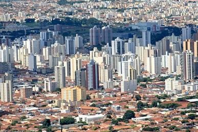
São José do Rio Preto ([sɐ̃w̃ ʒuˈzɛ du ʁiw ˈpɾetu]) is a municipality (cidade/município) in the state of São Paulo, Brazil. The city is located at the north/northwest portion of the state, 440 km (273 mi) from the city of São Paulo and 700 km (435 mi) from Brasília. With 408,258 inhabitants (IBGE/2010), is the 12th biggest city of the state and the 52nd biggest in Brazil.
Contents
- Map of Sao Jose do Rio Preto SC3A3o JosC3A9 do Rio Preto State of SC3A3o Paulo Brazil
- S o jos do rio preto s o paulo euro truck simulator
- History
- Origin of the name
- Geography
- Climate
- Neighbouring cities
- Economy
- Demographics
- Indicators
- Other statistics
- Culture
- Media
- Health
- Education
- Urban transport
- Infrastructure
- Sports
- Roads
- Air
- Twin towns Sister cities
- References
Map of Sao Jose do Rio Preto, S%C3%A3o Jos%C3%A9 do Rio Preto - State of S%C3%A3o Paulo, Brazil
Founded in 1852, its history is closely linked with trade, the provision of services and agriculture. In 1912, the railroad Araraquarense arrived and stopped in the city for 20 years, transforming São José do Rio Preto in the commercial center of the region.
Known as Rio Preto, is the center of a Mesoregion with 1,569,220 inhabitants in 29,387 km². The Microregion of São José do Rio Preto has a population of 763,534 inhabitants.
S o jos do rio preto s o paulo euro truck simulator
History
Before the 19th century, the region was inhabited by the Kaingang, an indigenous people, that was gradually reduced or assimilitated, due to migration, the bandeiras and miscegenation. In the 19th century, farmers from Minas Gerais settled in the region.
The city was founded on March 19, 1852, by João Bernardino de Seixas Ribeiro, after Luis Antônio da Silveira donated part of his lands to the Catholic Church, in tribute to Saint Joseph, aiming the creation of a city. These lands from the farm gave birth to the city.
In 1894, São José do Rio Preto was officially established as a municipality, with the emancipation from Jaboticabal. The newly created city had around 26,000 km². With the arrival of the railroad, the Estrada de Ferro Araraquarense, in 1912, the city became the commercial center of the region, stocking and radiating the goods from the region and the state capital.
Origin of the name
The literal translation is "Saint Joseph of the Black River". The city's name origin comes from the fact that Saint Joseph (São José) is the patron saint of the city, and the Rio Preto (Black river) cuts the city lands. A wooden sculpture of Saint Joseph wearing boots belongs to the city cathedral and no one knows for sure where it came from, but is in the city since it was a village in the 19th century, part of the city of Araraquara.
People believe that migrants from the state of Minas Gerais brought the sculpture with them in the 19th century, and that is the origin of part of the name. The river was believed black because there was a dense forest in the area, and even though the water was clear, the darkness made the river looks black. March 19, Rio Preto's birthday, is Saint Joseph's Day and a holiday in the city.
Between 1906 and 1944, the name was shortened to "Rio Preto" and in 1944 there was a proposal for changing the city's name to "Iboruna" (Black river in Tupi language), but the name returned to the current form.
Geography
The city is located on the region between the rivers Grande, Paraná and Tietê. The Vegetation is a mixture of Cerrado (Grass savanna) with traces of the Mata Atlântica (Atlantic Forest). The topography is formed by a slightly undulated relief, with a medium elevation of 489 m (1,604 ft).
Climate
According to the IBGE, the clime is Tropical sub-hot humid, characterized by a mild and dry winter, and hot, rainy summers.
At the Köppen climate classification, the city is on a Cwa (Humid subtropical climate or Highland tropical) area, although the annual average temperature is of 23 °C. The annual average precipitation varies between 1,300 and 1,500 mm. In 2008, there were 1,593 mm of rain.
Neighbouring cities
Economy
São José do Rio Preto is the biggest city of a region with strong agrarian tradition (Northwest of São Paulo). The city concentrates the Commerce and the specialized Service sector of the region. The Tertiary sector is the economic basis of the city. There are about 75 bank branches in the city. Hospitals, clinics, schools, universities, shopping centers (malls) and the commerce in general, attracts people from throughout the region and other parts of Brazil.
Agriculture and livestock (Primary sector) accounts for less than 1% of the GDP, but are relevant in the region. Sugarcane, natural rubber, oranges and corn are the most cultivated.
The Industry is formed by 3 major industrial districts, with the "Distrito Dr. Waldemar de Oliveira Verdi" being the biggest, and 13 smaller districts (mini distritos). There's a prevalence of small and medium businesses, with diversified production.
The GDP observed in 2009 was R$7,879,048,000.
84.53% of the GDP is generated by the Tertiary sector and 15.19% by the Industry.
Demographics
The HDI of the city, measured by the UNDP, was 0.834 in 2000, being 0.814 in Income, 0.916 in Education and 0.772 in Life expectancy. The HDI for Brazil was 0.766 in the year 2000. In 2008 there were 38 homicides in the city, making an homicide rate of 9.2/100 thousand inhabitants.
The city has 2 districts: Engenheiro Schmitt, with 17,680 inhabitants (2009), and Talhado, with 4,502 inhabitants (2009). São José do Rio Preto has about 360 neighbourhoods.
In 2010, the IBGE accounted 137,233 occupied and permanent households.
Indicators
All indicators are from SEADE and IBGE
Other statistics
Culture
The major Library of the city is the Biblioteca Pública Municipal "Dr. Fernando Costa", a public institution, and the major theater is the Teatro Municipal "Humberto Sinibaldi Neto". There are other theater venues, like the Paulo Moura Theater, located at the old Swift factory, and the SESI Theater.
A vegetable oil factory from the 1940s, the "Swift", is a public cultural center since 1983, when it was bought by the prefecture. In June, 2012, a new theater venue was opened at the "Swift", the Teatro Municipal "Paulo Moura", with 954 seats.
Annually, on July, the city holds its popular "International Festival of Amateur Theater". Foreign and Brazilian theater groups join the Festival, in presentations throughout the city, in traditional theaters, as well as open air stages and other less traditional performance venues.
Rodeos are popular throughout the region and the upstate, and Rio Preto has annual festivals of the genre.
The city has a lively nightlife with many bars and clubs offering different styles of music. One of the most popular hotspots in Rio Preto is the Rock bar "Vila Dionísio", which show cases local acts as well as tribute bands and themed events. The city hosts annually a LGBT parade, the "Parada do Orgulho GLSBT de Rio Preto", gathering thousands of people from the all parts of Brazil.
Media
Rio Preto has affiliates of the Rede Record and Rede Globo, and is the head office for Rede Vida (Life Network), a catholic television network with national presence. The city has a branch of the NET, a cable television operator.
There are two daily newspapers in the city, the Diário da Região (Region's Diary) and the Bom Dia (Good Day).
Health
There are 8 hospitals in São José do Rio Preto, with 1.681 beds. The Hospital de Base, a public institution, is the biggest hospital of the city.
Education
The city has 36 state schools and 51 private schools, from infant to secondary education, and 153 municipal schools, from infant to primary education. Rio Preto also has three public universities: a branch of the UNESP, called Ibilce, the FAMERP, specialized in Medicine, and the FATEC (Faculdades de Tecnologia do Estado de São Paulo). The city also has various private universities, such as Unirp, UNIP, Unorp, Unilago.
Urban transport
Rio Preto has 2 companies of mass urban transportation, the Circular Santa Luzia and the Expresso Itamarati. 300 buses operates daily, throughout the city.
Infrastructure
All indicators are from SEADE
Sports
There are two professional association football clubs in the city: América-SP and Rio Preto. América-SP usually plays at Teixeirão Stadium, which has a maximum capacity of 32,168 spectators. Rio Preto plays at Rio Pretão Stadium, which has a maximum capacity of 17,000 spectators.
The city has a number of public sport venues, including an arena with a capacity of 6,000 seated spectators, the "Centro Regional de Eventos" (Events Regional Center), 24 public football fields, an athletic track and bocce (bocha) courts. There's a wheelchair basketball team in the city, formed by members of the CAD (Friends of Disabled persons Club), competing at national level. The CAD also competes in other disabled sports.
Roads
Air
São José do Rio Preto is served by "Prof. Eribelto Manoel Reino Airport".